This weather event on November 24, 2025 includes:
1 states
25 counties,
25 cities,
and 72 zip codes.
There were 1539 total properties that were impacted and have possible damage.
States Impacted By Hail On November 24, 2025
Texas
Counties Impacted By Hail On November 24, 2025
Anderson, TX
·
Brazos, TX
·
Burleson, TX
·
Camp, TX
·
Cherokee, TX
·
Ellis, TX
·
Falls, TX
·
Franklin, TX
·
Freestone, TX
·
Henderson, TX
·
Hill, TX
·
Hopkins, TX
·
Houston, TX
·
Kaufman, TX
·
Leon, TX
·
Limestone, TX
·
McLennan, TX
·
Navarro, TX
·
Red River, TX
·
Robertson, TX
·
Smith, TX
·
Titus, TX
·
Upshur, TX
·
Van Zandt, TX
·
Wood, TX
Cities Impacted By Hail On November 24, 2025
Athens, TX
·
Brownsboro, TX
·
Canton, TX
·
Dawson, TX
·
Emhouse, TX
·
Eustace, TX
·
Fairfield, TX
·
Fruitvale, TX
·
Grand Saline, TX
·
Hallsburg, TX
·
Hearne, TX
·
Hubbard, TX
·
Kemp, TX
·
Kirvin, TX
·
Lindale, TX
·
Mabank, TX
·
Mart, TX
·
Mount Vernon, TX
·
Murchison, TX
·
Myrtle Springs, TX
·
Palestine, TX
·
Seven Points, TX
·
Streetman, TX
·
Talco, TX
·
Wortham, TX
Zip Codes Impacted By Hail On November 24, 2025
75147
·
75148
·
75169
·
75417
·
75455
·
75457
·
75482
·
75487
·
75497
·
75644
·
75686
·
75704
·
75706
·
75751
·
75752
·
75754
·
75756
·
75758
·
75770
·
75771
·
75778
·
75785
·
75801
·
75803
·
75831
·
75833
·
75835
·
75838
·
75839
·
75840
·
75846
·
75848
·
75853
·
75855
·
75859
·
75860
·
76632
·
76635
·
76639
·
76642
·
76648
·
76656
·
76661
·
76667
·
77836
·
77855
·
77856
·
77859
·
77865
·
77871
·
77808
·
77807
·
76705
·
76693
·
76687
·
76685
·
76682
·
76679
·
76678
·
76664
·
75861
·
75144
·
75143
·
75142
·
75140
·
75127
·
75124
·
75119
·
75117
·
75110
·
75105
·
75103
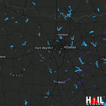 DALLAS/FTW (KFWS) RADAR

