This weather event on June 2, 2026 includes:
2 states
15 counties,
43 cities,
and 61 zip codes.
There were 3189 total properties that were impacted and have possible damage.
States Impacted By Hail On June 2, 2026
Kansas
·
Oklahoma
Counties Impacted By Hail On June 2, 2026
Cherokee, KS
·
Labette, KS
·
Montgomery, KS
·
Cherokee, OK
·
Craig, OK
·
Delaware, OK
·
Haskell, OK
·
Mayes, OK
·
McIntosh, OK
·
Muskogee, OK
·
Ottawa, OK
·
Rogers, OK
·
Tulsa, OK
·
Wagoner, OK
·
Washington, OK
Cities Impacted By Hail On June 2, 2026
Briggs, OK
·
Broken Arrow, OK
·
Bushyhead, OK
·
Checotah, OK
·
Claremore, OK
·
Cleora, OK
·
Collinsville, OK
·
Coweta, OK
·
Disney, OK
·
Duchess Landing, OK
·
Edna, KS
·
Eldon, OK
·
Fair Oaks, OK
·
Foyil, OK
·
Gideon, OK
·
Gregory, OK
·
Inola, OK
·
Jenks, OK
·
Ketchum, OK
·
Langley, OK
·
Lost City, OK
·
Miami, OK
·
Owasso, OK
·
Park Hill, OK
·
Peggs, OK
·
Pensacola, OK
·
Porter, OK
·
Redbird, OK
·
Rentiesville, OK
·
Salina, OK
·
Scraper, OK
·
Shady Grove, OK
·
Snake Creek, OK
·
Steely Hollow, OK
·
Strang, OK
·
Tahlequah, OK
·
Tulsa, OK
·
Vera, OK
·
Verdigris, OK
·
Wagoner, OK
·
Welling, OK
·
Woodall, OK
·
Zeb, OK
Zip Codes Impacted By Hail On June 2, 2026
74134
·
74332
·
74960
·
74472
·
74471
·
74469
·
74467
·
74464
·
74462
·
74459
·
74458
·
74457
·
74455
·
74454
·
74451
·
74450
·
74441
·
74436
·
74434
·
74429
·
74426
·
74369
·
74367
·
74366
·
74365
·
74364
·
74361
·
74354
·
74352
·
74350
·
74342
·
74340
·
74337
·
74331
·
74330
·
74301
·
74146
·
74145
·
74137
·
74136
·
74133
·
74129
·
74128
·
74108
·
74080
·
74053
·
74037
·
74036
·
74021
·
74019
·
74017
·
74016
·
74015
·
74014
·
74012
·
74008
·
67351
·
67342
·
67337
·
67336
·
67332
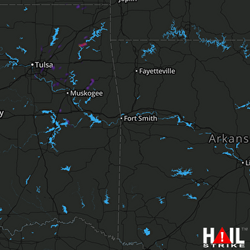 FORT SMITH (KSRX) RADAR

