This weather event on August 24, 2026 includes:
1 states
14 counties,
27 cities,
and 48 zip codes.
There were 1126 total properties that were impacted and have possible damage.
States Impacted By Hail On August 24, 2026
North Carolina
Counties Impacted By Hail On August 24, 2026
Beaufort, NC
·
Carteret, NC
·
Craven, NC
·
Currituck, NC
·
Dare, NC
·
Duplin, NC
·
Hyde, NC
·
Jones, NC
·
Lenoir, NC
·
Onslow, NC
·
Pamlico, NC
·
Pitt, NC
·
Tyrrell, NC
·
Washington, NC
Cities Impacted By Hail On August 24, 2026
Alliance, NC
·
Aurora, NC
·
Bayboro, NC
·
Bayview, NC
·
Brices Creek, NC
·
Chocowinity, NC
·
Creswell, NC
·
Duck, NC
·
Fairfield, NC
·
Frisco, NC
·
Grantsboro, NC
·
Hatteras, NC
·
Havelock, NC
·
Hobucken, NC
·
James City, NC
·
Minnesott Beach, NC
·
Neuse Forest, NC
·
New Bern, NC
·
Pinetown, NC
·
Pollocksville, NC
·
River Bend, NC
·
River Road, NC
·
Roper, NC
·
Stonewall, NC
·
Trent Woods, NC
·
Washington, NC
·
Washington Park, NC
Zip Codes Impacted By Hail On August 24, 2026
27806
·
27808
·
27810
·
27817
·
27821
·
27824
·
27826
·
27837
·
27858
·
27860
·
27865
·
27875
·
27885
·
27889
·
27925
·
27928
·
27936
·
27943
·
27949
·
27953
·
27960
·
27962
·
27966
·
27970
·
28349
·
28501
·
28504
·
28510
·
28513
·
28515
·
28516
·
28520
·
28525
·
28526
·
28529
·
28530
·
28532
·
28537
·
28552
·
28555
·
28556
·
28560
·
28562
·
28571
·
28572
·
28573
·
28583
·
28585
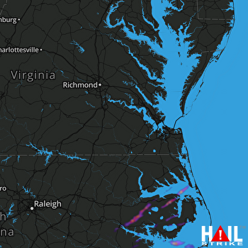 NORFOLK/RICH (KAKQ) RADAR

