This weather event on June 25, 2025 includes:
3 states
42 counties,
60 cities,
and 186 zip codes.
There were 337 total properties that were impacted and have possible damage.
States Impacted By Hail On June 25, 2025
Iowa
·
Minnesota
·
Nebraska
Counties Impacted By Hail On June 25, 2025
Buena Vista, IA
·
Calhoun, IA
·
Carroll, IA
·
Cedar, IA
·
Cerro Gordo, IA
·
Cherokee, IA
·
Chickasaw, IA
·
Clay, IA
·
Crawford, IA
·
Floyd, IA
·
Franklin, IA
·
Hamilton, IA
·
Hancock, IA
·
Harrison, IA
·
Howard, IA
·
Humboldt, IA
·
Ida, IA
·
Johnson, IA
·
Kossuth, IA
·
Mitchell, IA
·
Monona, IA
·
Muscatine, IA
·
O'Brien, IA
·
Palo Alto, IA
·
Plymouth, IA
·
Pocahontas, IA
·
Sac, IA
·
Washington, IA
·
Webster, IA
·
Winnebago, IA
·
Winneshiek, IA
·
Woodbury, IA
·
Worth, IA
·
Wright, IA
·
Faribault, MN
·
Fillmore, MN
·
Freeborn, MN
·
Mower, MN
·
Burt, NE
·
Dodge, NE
·
Thurston, NE
·
Washington, NE
Cities Impacted By Hail On June 25, 2025
Albert Lea, MN
·
Anthon, IA
·
Arthur, IA
·
Belmond, IA
·
Calumet, IA
·
Castana, IA
·
Cherokee, IA
·
Chester, IA
·
Craig, NE
·
Dakota City, IA
·
Decatur, NE
·
Early, IA
·
Emmetsburg, IA
·
Fertile, IA
·
Forest City, IA
·
Gillett Grove, IA
·
Gilmore City, IA
·
Goodell, IA
·
Hanlontown, IA
·
Hardy, IA
·
Hartland, MN
·
Humboldt, IA
·
Hutchins, IA
·
Lake Mills, IA
·
Le Roy, MN
·
Lime Springs, IA
·
Little Cedar, IA
·
Little Sioux, IA
·
Lone Rock, IA
·
Mapleton, IA
·
Mason City, IA
·
Miller, IA
·
Mitchell, IA
·
Nemaha, IA
·
Nickerson, NE
·
Oakland, NE
·
Onawa, IA
·
Osage, IA
·
Ostrander, MN
·
Oto, IA
·
Palmer, IA
·
Pioneer, IA
·
Pomeroy, IA
·
Renwick, IA
·
Riceville, IA
·
Riverside, IA
·
Rodney, IA
·
Rosalie, NE
·
Scarville, IA
·
Sexton, IA
·
Smithland, IA
·
Sutherland, IA
·
Tekamah, NE
·
Thompson, IA
·
Uehling, NE
·
Ute, IA
·
Varina, IA
·
Washington, IA
·
Washta, IA
·
West Liberty, IA
Zip Codes Impacted By Hail On June 25, 2025
50401
·
50420
·
50421
·
50423
·
50424
·
50430
·
50433
·
50434
·
50436
·
50438
·
50439
·
50440
·
50446
·
50447
·
50449
·
50450
·
50452
·
50453
·
50454
·
50455
·
50456
·
50458
·
50459
·
50460
·
50461
·
50464
·
50466
·
50469
·
50472
·
50473
·
50475
·
50476
·
50478
·
50480
·
50482
·
50483
·
50484
·
50511
·
50517
·
50520
·
50522
·
50524
·
50525
·
50528
·
50529
·
50535
·
50536
·
50539
·
50541
·
50542
·
50545
·
50548
·
50551
·
50559
·
50561
·
50563
·
50567
·
50571
·
50574
·
50575
·
50576
·
50577
·
50579
·
50582
·
50585
·
50591
·
50593
·
50595
·
50599
·
50603
·
50616
·
50628
·
50630
·
50645
·
50659
·
51002
·
51004
·
51005
·
51006
·
51009
·
51010
·
51012
·
51016
·
51018
·
51019
·
51020
·
51022
·
51025
·
51026
·
51029
·
51031
·
51033
·
51034
·
51035
·
51040
·
51044
·
51046
·
51047
·
51049
·
51050
·
51053
·
51056
·
51058
·
51060
·
51061
·
51063
·
51245
·
51301
·
51333
·
51343
·
51357
·
51358
·
51430
·
51431
·
51436
·
51439
·
51445
·
51448
·
51450
·
51458
·
51461
·
51523
·
51528
·
51529
·
51545
·
51557
·
51558
·
51564
·
51572
·
51579
·
52134
·
52136
·
52144
·
52154
·
52155
·
52163
·
52171
·
52201
·
52216
·
52240
·
52255
·
52327
·
52353
·
52358
·
52720
·
52721
·
52755
·
52772
·
52776
·
55909
·
55933
·
55936
·
55961
·
55975
·
55977
·
56007
·
56014
·
56029
·
56036
·
56042
·
56072
·
56097
·
68002
·
68008
·
68019
·
68020
·
68025
·
68029
·
68031
·
68038
·
68039
·
68044
·
68045
·
68055
·
68061
·
68063
·
68067
·
50428
·
50444
·
50540
·
50568
·
50583
·
51051
·
51341
·
51442
·
55951
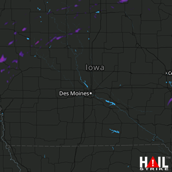 DES MOINES (KDMX) RADAR

