This weather event on April 23, 2025 includes:
4 states
48 counties,
60 cities,
and 218 zip codes.
There were 6776 total properties that were impacted and have possible damage.
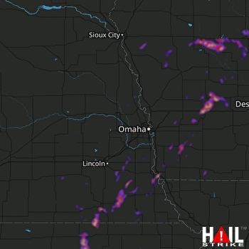 OMAHA (KOAX) RADAR
States Impacted By Hail On April 23, 2025
Iowa
·
Kansas
·
Missouri
·
Nebraska
Counties Impacted By Hail On April 23, 2025
Audubon, IA
·
Calhoun, IA
·
Carroll, IA
·
Cass, IA
·
Crawford, IA
·
Fremont, IA
·
Greene, IA
·
Guthrie, IA
·
Harrison, IA
·
Ida, IA
·
Mills, IA
·
Monona, IA
·
Montgomery, IA
·
Page, IA
·
Pottawattamie, IA
·
Sac, IA
·
Shelby, IA
·
Taylor, IA
·
Webster, IA
·
Woodbury, IA
·
Atchison, KS
·
Brown, KS
·
Clay, KS
·
Jackson, KS
·
Jefferson, KS
·
Marshall, KS
·
Nemaha, KS
·
Pottawatomie, KS
·
Riley, KS
·
Washington, KS
·
Burt, NE
·
Butler, NE
·
Cass, NE
·
Dodge, NE
·
Douglas, NE
·
Fillmore, NE
·
Gage, NE
·
Jefferson, NE
·
Johnson, NE
·
Lancaster, NE
·
Nemaha, NE
·
Otoe, NE
·
Pawnee, NE
·
Richardson, NE
·
Saline, NE
·
Sarpy, NE
·
Saunders, NE
·
Washington, NE
Cities Impacted By Hail On April 23, 2025
Audubon, IA
·
Bennet, NE
·
Blue Springs, NE
·
Brayton, IA
·
Burr, NE
·
Callender, IA
·
Ceresco, NE
·
Circleville, KS
·
Climbing Hill, IA
·
Coburg, IA
·
Coon Rapids, IA
·
Corning, KS
·
Crab Orchard, NE
·
Delia, KS
·
Effingham, KS
·
Elliott, IA
·
Elmwood, NE
·
Emerson, IA
·
Exeter, NE
·
Exira, IA
·
Filley, NE
·
Fort Dodge, IA
·
Gowrie, IA
·
Green, KS
·
Griswold, IA
·
Guthrie Center, IA
·
Herman, NE
·
Holton, KS
·
Imogene, IA
·
Jansen, NE
·
Jefferson, IA
·
Johnson, NE
·
Julian, NE
·
Knierim, IA
·
Lake City, IA
·
Linn, KS
·
Louisville, KS
·
Lytton, IA
·
Malvern, IA
·
Mondamin, IA
·
Morrowville, KS
·
Nortonville, KS
·
Palmer, KS
·
Palmyra, NE
·
Panama, NE
·
Paton, IA
·
Pawnee City, NE
·
Pisgah, IA
·
Red Oak, IA
·
Ricketts, IA
·
Rising City, NE
·
Rockwell City, IA
·
Sac City, IA
·
Sidney, IA
·
Twin Lakes, IA
·
Virginia, NE
·
Westmoreland, KS
·
Woodland Hills, NE
·
Wymore, NE
·
Yetter, IA
Zip Codes Impacted By Hail On April 23, 2025
50002
·
50020
·
50022
·
50025
·
50026
·
50029
·
50042
·
50048
·
50058
·
50076
·
50115
·
50117
·
50217
·
50274
·
50501
·
50516
·
50523
·
50532
·
50535
·
50543
·
50544
·
50551
·
50561
·
50563
·
50566
·
50575
·
50583
·
50586
·
50594
·
50843
·
50864
·
51004
·
51006
·
51019
·
51026
·
51034
·
51039
·
51060
·
51401
·
51433
·
51439
·
51440
·
51441
·
51442
·
51445
·
51446
·
51447
·
51448
·
51449
·
51450
·
51453
·
51458
·
51462
·
51465
·
51525
·
51531
·
51532
·
51533
·
51535
·
51536
·
51537
·
51540
·
51544
·
51545
·
51551
·
51552
·
51553
·
51557
·
51558
·
51560
·
51561
·
51564
·
51565
·
51566
·
51570
·
51573
·
51575
·
51577
·
51632
·
51638
·
51639
·
51640
·
51645
·
51646
·
51648
·
51649
·
51652
·
51653
·
51654
·
66023
·
66041
·
66060
·
66088
·
66411
·
66412
·
66415
·
66416
·
66417
·
66418
·
66419
·
66422
·
66424
·
66425
·
66427
·
66434
·
66436
·
66440
·
66449
·
66503
·
66509
·
66515
·
66516
·
66520
·
66527
·
66536
·
66540
·
66544
·
66547
·
66548
·
66549
·
66550
·
66552
·
66554
·
66943
·
66944
·
66945
·
66946
·
66953
·
66958
·
66962
·
67432
·
67447
·
68002
·
68003
·
68008
·
68017
·
68022
·
68025
·
68028
·
68029
·
68031
·
68037
·
68041
·
68048
·
68061
·
68064
·
68066
·
68069
·
68073
·
68301
·
68305
·
68310
·
68317
·
68318
·
68320
·
68323
·
68324
·
68328
·
68329
·
68332
·
68333
·
68341
·
68342
·
68343
·
68344
·
68345
·
68348
·
68349
·
68350
·
68351
·
68352
·
68354
·
68357
·
68358
·
68372
·
68376
·
68377
·
68378
·
68379
·
68402
·
68407
·
68409
·
68410
·
68413
·
68415
·
68418
·
68419
·
68420
·
68421
·
68428
·
68430
·
68433
·
68440
·
68441
·
68443
·
68446
·
68447
·
68448
·
68450
·
68454
·
68458
·
68463
·
68465
·
68466
·
68524
·
68526
·
68632
·
68658
·
50129
·
50538
·
50579
·
51543
·
51563
·
51631
·
66535
·
66933
·
66968
·
68347

