This weather event on May 15, 2024 includes:
2 states
26 counties,
25 cities,
and 81 zip codes.
There were 563 total properties that were impacted and have possible damage.
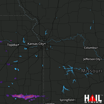 KANSAS CITY (KEAX) RADAR
States Impacted By Hail On May 15, 2024
Kansas
·
Missouri
Counties Impacted By Hail On May 15, 2024
Anderson, KS
·
Butler, KS
·
Chase, KS
·
Cherokee, KS
·
Coffey, KS
·
Crawford, KS
·
Elk, KS
·
Greenwood, KS
·
Jackson, KS
·
Johnson, KS
·
Labette, KS
·
Lyon, KS
·
Montgomery, KS
·
Morris, KS
·
Neosho, KS
·
Pottawatomie, KS
·
Riley, KS
·
Shawnee, KS
·
Wabaunsee, KS
·
Wilson, KS
·
Woodson, KS
·
Barton, MO
·
Dade, MO
·
Jasper, MO
·
Lafayette, MO
·
Newton, MO
Cities Impacted By Hail On May 15, 2024
Admire, KS
·
Altamont, KS
·
Cherokee, KS
·
Chicopee, KS
·
Columbus, KS
·
Cottonwood Falls, KS
·
Council Grove, KS
·
Elk Falls, KS
·
Emporia, KS
·
Eureka, KS
·
Galena, KS
·
Labette, KS
·
Leawood, KS
·
Lebo, KS
·
Leonardville, KS
·
LeRoy, KS
·
Manhattan, KS
·
McCune, KS
·
Neodesha, KS
·
Neosho Rapids, KS
·
Overland Park, KS
·
Parsons, KS
·
Pittsburg, KS
·
Riverton, KS
·
St. George, KS
Zip Codes Impacted By Hail On May 15, 2024
64001
·
64096
·
64832
·
64834
·
64844
·
64855
·
64870
·
64873
·
65682
·
66032
·
66093
·
66206
·
66210
·
66211
·
66213
·
66401
·
66418
·
66423
·
66502
·
66503
·
66506
·
66531
·
66533
·
66535
·
66536
·
66547
·
66554
·
66710
·
66713
·
66724
·
66725
·
66736
·
66739
·
66740
·
66743
·
66753
·
66757
·
66760
·
66762
·
66770
·
66771
·
66776
·
66777
·
66781
·
66783
·
66801
·
66830
·
66833
·
66839
·
66843
·
66845
·
66846
·
66850
·
66852
·
66856
·
66857
·
66864
·
66868
·
66869
·
66873
·
67045
·
67132
·
67301
·
67330
·
67335
·
67336
·
67341
·
67342
·
67344
·
67345
·
67349
·
67352
·
67354
·
67356
·
67357
·
67363
·
67074
·
66853
·
66449
·
65723
·
64755

