This weather event on October 21, 2026 includes:
2 states
10 counties,
31 cities,
and 81 zip codes.
There were 1496 total properties that were impacted and have possible damage.
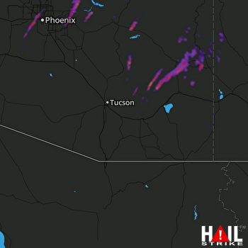 TUCSON (KEMX) RADAR
States Impacted By Hail On October 21, 2026
Arizona
·
New Mexico
Counties Impacted By Hail On October 21, 2026
Cochise, AZ
·
Gila, AZ
·
Graham, AZ
·
Greenlee, AZ
·
Maricopa, AZ
·
Pima, AZ
·
Pinal, AZ
·
Catron, NM
·
Grant, NM
·
Hidalgo, NM
Cities Impacted By Hail On October 21, 2026
Apache Junction, AZ
·
Avondale, AZ
·
Cactus Flats, AZ
·
Central, AZ
·
Clifton, AZ
·
Fountain Hills, AZ
·
Gilbert, AZ
·
Glendale, AZ
·
Glenwood, NM
·
Goodyear, AZ
·
Maricopa Colony, AZ
·
Mesa, AZ
·
Morenci, AZ
·
Peridot, AZ
·
Phoenix, AZ
·
Pima, AZ
·
Pleasanton, NM
·
Queen Creek, AZ
·
Rodeo, NM
·
Safford, AZ
·
San Carlos, AZ
·
San Jose, AZ
·
San Manuel, AZ
·
Scottsdale, AZ
·
Sierra Vista, AZ
·
Sierra Vista Southeast, AZ
·
Solomon, AZ
·
Swift Trail Junction, AZ
·
Tolleson, AZ
·
Tonto Basin, AZ
·
York, AZ
Zip Codes Impacted By Hail On October 21, 2026
85015
·
85017
·
85019
·
85020
·
85021
·
85022
·
85023
·
85029
·
85031
·
85032
·
85033
·
85035
·
85043
·
85050
·
85051
·
85054
·
85118
·
85120
·
85140
·
85142
·
85143
·
85192
·
85206
·
85207
·
85208
·
85209
·
85212
·
85213
·
85215
·
85234
·
85255
·
85262
·
85263
·
85264
·
85268
·
85295
·
85297
·
85301
·
85302
·
85303
·
85323
·
85326
·
85338
·
85339
·
85353
·
85501
·
85531
·
85533
·
85534
·
85540
·
85541
·
85542
·
85543
·
85545
·
85546
·
85550
·
85551
·
85553
·
85554
·
85602
·
85605
·
85616
·
85618
·
85619
·
85623
·
85631
·
85632
·
85635
·
85638
·
85641
·
85643
·
85650
·
85941
·
88020
·
88039
·
88040
·
88045
·
88051
·
88055
·
88056
·
88061