This weather event on June 20, 2026 includes:
3 states
20 counties,
16 cities,
and 60 zip codes.
There were total properties that were impacted and have possible damage.
States Impacted By Hail On June 20, 2026
Kansas
·
Missouri
·
Nebraska
Counties Impacted By Hail On June 20, 2026
Atchison, KS
·
Brown, KS
·
Doniphan, KS
·
Douglas, KS
·
Franklin, KS
·
Geary, KS
·
Jackson, KS
·
Linn, KS
·
Lyon, KS
·
Marshall, KS
·
Miami, KS
·
Morris, KS
·
Nemaha, KS
·
Osage, KS
·
Pottawatomie, KS
·
Riley, KS
·
Shawnee, KS
·
Wabaunsee, KS
·
Holt, MO
·
Pawnee, NE
Cities Impacted By Hail On June 20, 2026
Baldwin City, KS
·
Fairview, KS
·
Hiawatha, KS
·
Highland, KS
·
Linn Valley, KS
·
Manhattan, KS
·
Netawaka, KS
·
Ogden, KS
·
Oneida, KS
·
Osage City, KS
·
Ottawa, KS
·
Randolph, KS
·
Robinson, KS
·
Sabetha, KS
·
Summerfield, KS
·
Wakarusa, KS
Zip Codes Impacted By Hail On June 20, 2026
66618
·
66407
·
66076
·
68420
·
68381
·
68323
·
66868
·
66846
·
66834
·
66830
·
66554
·
66552
·
66550
·
66547
·
66546
·
66544
·
66541
·
66539
·
66538
·
66537
·
66536
·
66534
·
66532
·
66527
·
66523
·
66522
·
66518
·
66517
·
66516
·
66515
·
66509
·
66506
·
66503
·
66502
·
66449
·
66442
·
66439
·
66436
·
66434
·
66427
·
66425
·
66424
·
66422
·
66414
·
66413
·
66408
·
66406
·
66404
·
66403
·
66401
·
66095
·
66092
·
66087
·
66067
·
66041
·
66040
·
66035
·
66023
·
66006
·
64473
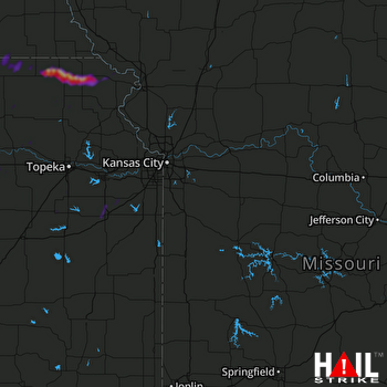 KANSAS CITY (KEAX) RADAR

