This weather event on May 10, 2026 includes:
1 states
19 counties,
20 cities,
and 76 zip codes.
There were 815 total properties that were impacted and have possible damage.
States Impacted By Hail On May 10, 2026
Arkansas
Counties Impacted By Hail On May 10, 2026
Clark, AR
·
Cleburne, AR
·
Conway, AR
·
Crawford, AR
·
Dallas, AR
·
Faulkner, AR
·
Franklin, AR
·
Johnson, AR
·
Madison, AR
·
Newton, AR
·
Perry, AR
·
Pope, AR
·
Pulaski, AR
·
Saline, AR
·
Searcy, AR
·
Van Buren, AR
·
Washington, AR
·
White, AR
·
Yell, AR
Cities Impacted By Hail On May 10, 2026
Center Ridge, AR
·
Clinton, AR
·
Conway, AR
·
Damascus, AR
·
Dardanelle, AR
·
Dennard, AR
·
Enola, AR
·
Greenbrier, AR
·
Guy, AR
·
Heber Springs, AR
·
Little Rock, AR
·
Maumelle, AR
·
Mayflower, AR
·
Menifee, AR
·
Natural Steps, AR
·
North Little Rock, AR
·
Perryville, AR
·
Russellville, AR
·
Twin Groves, AR
·
West Fork, AR
Zip Codes Impacted By Hail On May 10, 2026
72212
·
72032
·
71923
·
71720
·
72959
·
72949
·
72947
·
72856
·
72854
·
72846
·
72843
·
72839
·
72837
·
72834
·
72830
·
72823
·
72802
·
72801
·
72774
·
72753
·
72752
·
72742
·
72701
·
72686
·
72670
·
72666
·
72645
·
72641
·
72629
·
72543
·
72223
·
72211
·
72210
·
72209
·
72207
·
72206
·
72205
·
72204
·
72202
·
72201
·
72181
·
72173
·
72157
·
72143
·
72141
·
72137
·
72136
·
72135
·
72131
·
72127
·
72126
·
72122
·
72118
·
72114
·
72113
·
72111
·
72107
·
72106
·
72102
·
72080
·
72070
·
72063
·
72061
·
72058
·
72047
·
72039
·
72034
·
72031
·
72030
·
72027
·
72019
·
72016
·
72013
·
72012
·
71763
·
71742
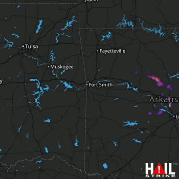 FORT SMITH (KSRX) RADAR

