This weather event on April 30, 2026 includes:
1 states
24 counties,
19 cities,
and 74 zip codes.
There were 6642 total properties that were impacted and have possible damage.
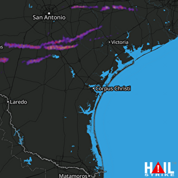 CORP CHRISTI (KCRP) RADAR
States Impacted By Hail On April 30, 2026
Texas
Counties Impacted By Hail On April 30, 2026
Atascosa, TX
·
Bee, TX
·
Bexar, TX
·
Colorado, TX
·
DeWitt, TX
·
Dimmit, TX
·
Frio, TX
·
Goliad, TX
·
Gonzales, TX
·
Guadalupe, TX
·
Jackson, TX
·
Jim Wells, TX
·
Karnes, TX
·
La Salle, TX
·
Lavaca, TX
·
Live Oak, TX
·
McMullen, TX
·
Nueces, TX
·
San Patricio, TX
·
Victoria, TX
·
Webb, TX
·
Wharton, TX
·
Wilson, TX
·
Zavala, TX
Cities Impacted By Hail On April 30, 2026
Asherton, TX
·
Christine, TX
·
Cibolo, TX
·
Corpus Christi, TX
·
Cuero, TX
·
Fowlerton, TX
·
Gonzales, TX
·
Hilltop, TX
·
Karnes City, TX
·
Kenedy, TX
·
Kingsbury, TX
·
Leming, TX
·
Marion, TX
·
Moulton, TX
·
Pleasanton, TX
·
Runge, TX
·
Santa Clara, TX
·
Seguin, TX
·
Yorktown, TX
Zip Codes Impacted By Hail On April 30, 2026
78151
·
77957
·
77434
·
77412
·
78962
·
78959
·
78956
·
78951
·
78934
·
78839
·
78836
·
78834
·
78830
·
78829
·
78827
·
78648
·
78638
·
78632
·
78629
·
78410
·
78409
·
78390
·
78387
·
78380
·
78374
·
78370
·
78368
·
78332
·
78264
·
78164
·
78155
·
78141
·
78130
·
78124
·
78119
·
78118
·
78117
·
78114
·
78113
·
78108
·
78075
·
78072
·
78071
·
78065
·
78064
·
78061
·
78050
·
78045
·
78026
·
78021
·
78019
·
78017
·
78014
·
78012
·
78011
·
78008
·
78005
·
78001
·
77995
·
77993
·
77984
·
77976
·
77975
·
77974
·
77968
·
77964
·
77963
·
77954
·
77905
·
77904
·
77475
·
77470
·
77454
·
77442

