This weather event on April 30, 2026 includes:
2 states
20 counties,
17 cities,
and 60 zip codes.
There were 5288 total properties that were impacted and have possible damage.
States Impacted By Hail On April 30, 2026
Louisiana
·
Texas
Counties Impacted By Hail On April 30, 2026
Beauregard, LA
·
Calcasieu, LA
·
Vernon, LA
·
Angelina, TX
·
Bastrop, TX
·
Brazos, TX
·
Grimes, TX
·
Houston, TX
·
Jasper, TX
·
Madison, TX
·
Milam, TX
·
Newton, TX
·
Polk, TX
·
Robertson, TX
·
Sabine, TX
·
San Augustine, TX
·
San Jacinto, TX
·
Trinity, TX
·
Tyler, TX
·
Walker, TX
Cities Impacted By Hail On April 30, 2026
Broaddus, TX
·
Browndell, TX
·
Burke, TX
·
Cedar Point, TX
·
Chester, TX
·
Gillis, LA
·
Huntsville, TX
·
Indian Springs, TX
·
Iowa, LA
·
Lake Charles, LA
·
Livingston, TX
·
Merryville, LA
·
Moss Bluff, LA
·
Onalaska, TX
·
Riverside, TX
·
Westlake, LA
·
West Livingston, TX
Zip Codes Impacted By Hail On April 30, 2026
77360
·
70657
·
70601
·
78650
·
78621
·
78602
·
77872
·
77861
·
77859
·
77856
·
77831
·
77808
·
77664
·
77660
·
77624
·
77367
·
77364
·
77359
·
77351
·
77350
·
77340
·
77334
·
77331
·
77320
·
76520
·
75979
·
75977
·
75960
·
75951
·
75949
·
75948
·
75941
·
75939
·
75936
·
75934
·
75932
·
75931
·
75930
·
75929
·
75928
·
75926
·
75904
·
75901
·
75862
·
75852
·
75851
·
75847
·
75845
·
75835
·
71446
·
70669
·
70668
·
70663
·
70653
·
70647
·
70639
·
70634
·
70633
·
70615
·
70611
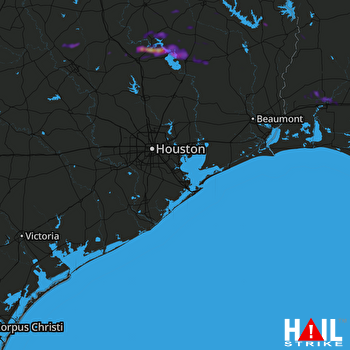 HOUSTON (KHGX) RADAR

