This weather event on April 9, 2026 includes:
4 states
35 counties,
71 cities,
and 179 zip codes.
There were 2702 total properties that were impacted and have possible damage.
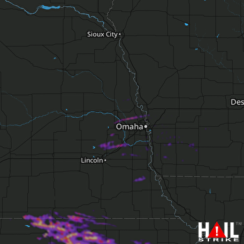 OMAHA (KOAX) RADAR
States Impacted By Hail On April 9, 2026
Iowa
·
Kansas
·
Missouri
·
Nebraska
Counties Impacted By Hail On April 9, 2026
Cass, IA
·
Fremont, IA
·
Harrison, IA
·
Mills, IA
·
Montgomery, IA
·
Page, IA
·
Pottawattamie, IA
·
Shelby, IA
·
Taylor, IA
·
Clay, KS
·
Cloud, KS
·
Jackson, KS
·
Jewell, KS
·
Marshall, KS
·
Nemaha, KS
·
Pottawatomie, KS
·
Republic, KS
·
Riley, KS
·
Washington, KS
·
Nodaway, MO
·
Cass, NE
·
Dodge, NE
·
Douglas, NE
·
Gage, NE
·
Jefferson, NE
·
Johnson, NE
·
Lancaster, NE
·
Nemaha, NE
·
Nuckolls, NE
·
Otoe, NE
·
Sarpy, NE
·
Saunders, NE
·
Thayer, NE
·
Washington, NE
·
Webster, NE
Cities Impacted By Hail On April 9, 2026
Agenda, KS
·
Alvo, NE
·
Ashland, NE
·
Barnes, KS
·
Bartlett, IA
·
Belleville, KS
·
Bellevue, NE
·
Bennington, NE
·
Bentley, IA
·
Blue Rapids, KS
·
Byron, NE
·
Carter Lake, IA
·
Cedar Creek, NE
·
Centralia, KS
·
Ceresco, NE
·
Chester, NE
·
Clifton, KS
·
Concordia, KS
·
Cook, NE
·
Corning, KS
·
Council Bluffs, IA
·
Crescent, IA
·
Cuba, KS
·
Davey, NE
·
Diller, NE
·
Endicott, NE
·
Goff, KS
·
Greenleaf, KS
·
Gretna, NE
·
Haddam, KS
·
Hardy, NE
·
Hastings, IA
·
Henderson, IA
·
Hollenberg, KS
·
Ithaca, NE
·
La Platte, NE
·
Leshara, NE
·
Linn, KS
·
Lorton, NE
·
Mahaska, KS
·
Malvern, IA
·
Mineola, IA
·
Munden, KS
·
Narka, KS
·
Offutt AFB, NE
·
Olsburg, KS
·
Omaha, NE
·
Palmer, KS
·
Papillion, NE
·
Plattsmouth, NE
·
Randolph, IA
·
Red Oak, IA
·
Republic, KS
·
Reynolds, NE
·
Richfield, NE
·
Scandia, KS
·
Shenandoah, IA
·
Silver City, IA
·
South Bend, NE
·
Stanton, IA
·
Steele City, NE
·
Superior, NE
·
Talmage, NE
·
Vermillion, KS
·
Villisca, IA
·
Washington, KS
·
Washington, NE
·
Waterville, KS
·
Webber, KS
·
Weeping Water, NE
·
Wetmore, KS
Zip Codes Impacted By Hail On April 9, 2026
68462
·
68066
·
68025
·
66933
·
66547
·
66438
·
51549
·
51534
·
68514
·
68978
·
68970
·
68943
·
68942
·
68527
·
68517
·
68466
·
68463
·
68455
·
68448
·
68446
·
68440
·
68428
·
68417
·
68415
·
68413
·
68410
·
68409
·
68407
·
68382
·
68375
·
68370
·
68366
·
68352
·
68350
·
68349
·
68346
·
68342
·
68340
·
68336
·
68329
·
68327
·
68325
·
68320
·
68307
·
68304
·
68152
·
68142
·
68138
·
68133
·
68131
·
68123
·
68122
·
68118
·
68113
·
68112
·
68110
·
68102
·
68073
·
68069
·
68068
·
68065
·
68064
·
68059
·
68058
·
68048
·
68046
·
68041
·
68037
·
68034
·
68033
·
68031
·
68029
·
68028
·
68023
·
68022
·
68018
·
68017
·
68016
·
68008
·
68007
·
68005
·
68003
·
68002
·
67447
·
67432
·
67417
·
66970
·
66968
·
66966
·
66964
·
66963
·
66962
·
66960
·
66959
·
66958
·
66955
·
66953
·
66948
·
66946
·
66945
·
66944
·
66943
·
66942
·
66940
·
66939
·
66938
·
66937
·
66936
·
66935
·
66930
·
66901
·
66554
·
66552
·
66550
·
66549
·
66548
·
66544
·
66540
·
66521
·
66520
·
66518
·
66516
·
66509
·
66508
·
66449
·
66436
·
66432
·
66428
·
66427
·
66422
·
66418
·
66417
·
66416
·
66415
·
66412
·
66411
·
66406
·
64461
·
51654
·
51653
·
51652
·
51649
·
51645
·
51639
·
51638
·
51636
·
51601
·
51579
·
51576
·
51575
·
51573
·
51571
·
51570
·
51566
·
51563
·
51561
·
51559
·
51555
·
51554
·
51553
·
51551
·
51548
·
51542
·
51541
·
51540
·
51537
·
51536
·
51535
·
51533
·
51526
·
51525
·
51521
·
51510
·
51503
·
51501
·
50864
·
50853
·
50843
·
50833

