This weather event on March 5, 2026 includes:
4 states
48 counties,
54 cities,
and 191 zip codes.
There were 1215 total properties that were impacted and have possible damage.
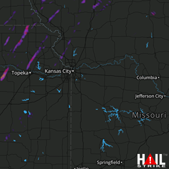 KANSAS CITY (KEAX) RADAR
States Impacted By Hail On March 5, 2026
Iowa
·
Kansas
·
Missouri
·
Nebraska
Counties Impacted By Hail On March 5, 2026
Fremont, IA
·
Page, IA
·
Ringgold, IA
·
Taylor, IA
·
Wayne, IA
·
Anderson, KS
·
Atchison, KS
·
Brown, KS
·
Chase, KS
·
Coffey, KS
·
Doniphan, KS
·
Franklin, KS
·
Geary, KS
·
Greenwood, KS
·
Jackson, KS
·
Jefferson, KS
·
Leavenworth, KS
·
Lyon, KS
·
Marshall, KS
·
Miami, KS
·
Morris, KS
·
Nemaha, KS
·
Osage, KS
·
Pottawatomie, KS
·
Riley, KS
·
Shawnee, KS
·
Wabaunsee, KS
·
Woodson, KS
·
Adair, MO
·
Andrew, MO
·
Atchison, MO
·
Buchanan, MO
·
Clinton, MO
·
Daviess, MO
·
DeKalb, MO
·
Gentry, MO
·
Harrison, MO
·
Holt, MO
·
Linn, MO
·
Mercer, MO
·
Nodaway, MO
·
Platte, MO
·
Putnam, MO
·
Worth, MO
·
Johnson, NE
·
Nemaha, NE
·
Pawnee, NE
·
Richardson, NE
Cities Impacted By Hail On March 5, 2026
Albany, MO
·
Allendale, MO
·
Amazonia, MO
·
Burlington, KS
·
Cainsville, MO
·
Camden Point, MO
·
Centralia, KS
·
Circleville, KS
·
Climax, KS
·
Clyde, MO
·
Conception Junction, MO
·
Corning, KS
·
Dearborn, MO
·
Denison, KS
·
Denton, KS
·
Du Bois, NE
·
Dwight, KS
·
Easton, MO
·
Effingham, KS
·
Elk Creek, NE
·
Eureka, KS
·
Fairfax, MO
·
Falls City, NE
·
Goff, KS
·
Graham, MO
·
Havensville, KS
·
Hoyt, KS
·
Kirksville, MO
·
Lancaster, KS
·
Lansing, KS
·
Leavenworth, KS
·
Maitland, MO
·
Manhattan, KS
·
Maryville, MO
·
Milford, KS
·
Mount Moriah, MO
·
New Market, IA
·
Ogden, KS
·
Osawatomie, KS
·
Parkerville, KS
·
Phelps City, MO
·
Platte City, MO
·
Randolph, KS
·
Ridgeway, MO
·
Sabetha, KS
·
Severance, KS
·
St. Joseph, MO
·
Summerfield, KS
·
Tarkio, MO
·
Tracy, MO
·
Vermillion, KS
·
Westboro, MO
·
Weston, MO
·
Yorktown, IA
Zip Codes Impacted By Hail On March 5, 2026
50147
·
50848
·
50854
·
50860
·
51601
·
51630
·
51636
·
51638
·
51640
·
51646
·
63533
·
64079
·
64098
·
64401
·
64402
·
64420
·
64421
·
64422
·
64423
·
64424
·
64426
·
64428
·
64430
·
64431
·
64432
·
64434
·
64437
·
64438
·
64439
·
64441
·
64442
·
64443
·
64445
·
64446
·
64448
·
64451
·
64453
·
64454
·
64455
·
64456
·
64457
·
64458
·
64459
·
64466
·
64468
·
64469
·
64470
·
64475
·
64479
·
64481
·
64482
·
64486
·
64491
·
64494
·
64498
·
64503
·
64506
·
64507
·
64661
·
64672
·
64673
·
66002
·
66008
·
66017
·
66020
·
66027
·
66032
·
66035
·
66041
·
66048
·
66058
·
66064
·
66078
·
66086
·
66087
·
66088
·
66090
·
66093
·
66095
·
66401
·
66422
·
66424
·
66425
·
66428
·
66432
·
66434
·
66436
·
66439
·
66440
·
66441
·
66506
·
66509
·
66510
·
66514
·
66515
·
66517
·
66520
·
66526
·
66528
·
66531
·
66532
·
66533
·
66534
·
66535
·
66536
·
66538
·
66539
·
66540
·
66541
·
66544
·
66547
·
66549
·
66550
·
66554
·
66618
·
66777
·
66783
·
66834
·
66838
·
66839
·
66846
·
66849
·
66850
·
66852
·
66853
·
66854
·
66857
·
66860
·
66870
·
67045
·
67122
·
67137
·
67449
·
68305
·
68320
·
68323
·
68345
·
68348
·
68441
·
68447
·
50133
·
50140
·
51632
·
51647
·
51656
·
63501
·
63546
·
64018
·
64463
·
64485
·
64487
·
64489
·
64490
·
64505
·
64628
·
64631
·
64632
·
64642
·
64657
·
64670
·
66023
·
66067
·
66403
·
66404
·
66406
·
66407
·
66411
·
66415
·
66416
·
66417
·
66418
·
66419
·
66427
·
66442
·
66449
·
66502
·
66503
·
66521
·
66871
·
66872
·
66873
·
67047
·
68355
·
68376
·
68378
·
68381
·
68414
·
68420
·
68431
·
68433
·
68437

