This weather event on November 9, 2025 includes:
3 states
29 counties,
23 cities,
and 73 zip codes.
There were 2164 total properties that were impacted and have possible damage.
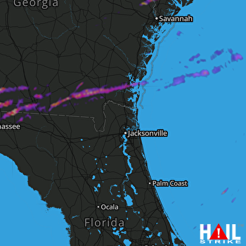 JACKSONVILLE (KJAX) RADAR
States Impacted By Hail On November 9, 2025
Florida
·
Georgia
·
South Carolina
Counties Impacted By Hail On November 9, 2025
Brevard, FL
·
Hamilton, FL
·
Jefferson, FL
·
Leon, FL
·
Madison, FL
·
Volusia, FL
·
Berrien, GA
·
Brantley, GA
·
Brooks, GA
·
Bulloch, GA
·
Camden, GA
·
Charlton, GA
·
Clinch, GA
·
Colquitt, GA
·
Cook, GA
·
Echols, GA
·
Effingham, GA
·
Evans, GA
·
Glynn, GA
·
Grady, GA
·
Lanier, GA
·
Liberty, GA
·
Lowndes, GA
·
McIntosh, GA
·
Tattnall, GA
·
Thomas, GA
·
Ware, GA
·
Wayne, GA
·
Jasper, SC
Cities Impacted By Hail On November 9, 2025
Berlin, GA
·
Boston, GA
·
Brunswick, GA
·
Cecil, GA
·
Coolidge, GA
·
Dasher, GA
·
Echols County, GA
·
Guyton, GA
·
Hahira, GA
·
Hardeeville, SC
·
Homeland, GA
·
Lakeland, GA
·
Lake Park, GA
·
Lloyd, FL
·
Monticello, FL
·
Oak Hill, FL
·
Quitman, GA
·
Ridgeland, SC
·
Rincon, GA
·
Springfield, GA
·
Thomasville, GA
·
Valdosta, GA
·
Woodbine, GA
Zip Codes Impacted By Hail On November 9, 2025
30417
·
30421
·
30427
·
30436
·
30453
·
31308
·
31312
·
31321
·
31329
·
31331
·
31503
·
31520
·
31522
·
31523
·
31527
·
31537
·
31542
·
31543
·
31550
·
31553
·
31565
·
31566
·
31568
·
31569
·
31601
·
31602
·
31605
·
31606
·
31620
·
31630
·
31631
·
31632
·
31634
·
31643
·
31645
·
31648
·
31649
·
31720
·
31722
·
31738
·
31757
·
31765
·
31768
·
31773
·
31778
·
31788
·
31792
·
32053
·
32309
·
32311
·
32336
·
32340
·
32344
·
32350
·
32754
·
32759
·
32764
·
39828
·
32331
·
32317
·
31641
·
31638
·
31636
·
31635
·
31629
·
31627
·
31626
·
31625
·
31326
·
30415
·
29943
·
29936
·
29927

