This weather event on October 18, 2025 includes:
2 states
19 counties,
18 cities,
and 55 zip codes.
There were total properties that were impacted and have possible damage.
States Impacted By Hail On October 18, 2025
Louisiana
·
Texas
Counties Impacted By Hail On October 18, 2025
Angelina, TX
·
Brazos, TX
·
Burleson, TX
·
Cherokee, TX
·
Grimes, TX
·
Houston, TX
·
Jasper, TX
·
Lee, TX
·
Leon, TX
·
Madison, TX
·
Nacogdoches, TX
·
Polk, TX
·
Robertson, TX
·
Sabine, TX
·
San Augustine, TX
·
San Jacinto, TX
·
Trinity, TX
·
Tyler, TX
·
Walker, TX
Cities Impacted By Hail On October 18, 2025
Bedias, TX
·
Burke, TX
·
Crockett, TX
·
Diboll, TX
·
Franklin, TX
·
Groveton, TX
·
Hudson, TX
·
Indian Springs, TX
·
Jasper, TX
·
Kurten, TX
·
Latexo, TX
·
Lufkin, TX
·
Midway, TX
·
Normangee, TX
·
Seven Oaks, TX
·
Trinity, TX
·
Wells, TX
·
Westwood Shores, TX
Zip Codes Impacted By Hail On October 18, 2025
75831
·
75833
·
75835
·
75839
·
75844
·
75845
·
75846
·
75847
·
75849
·
75850
·
75851
·
75852
·
75855
·
75856
·
75858
·
75862
·
75901
·
75904
·
75925
·
75926
·
75930
·
75937
·
75939
·
75941
·
75943
·
75948
·
75949
·
75951
·
75960
·
75961
·
75964
·
75968
·
75969
·
75972
·
75976
·
75979
·
76629
·
76653
·
77320
·
77350
·
77351
·
77360
·
77808
·
77831
·
77836
·
77837
·
77853
·
77856
·
77859
·
77861
·
77864
·
77865
·
77871
·
77872
·
78947
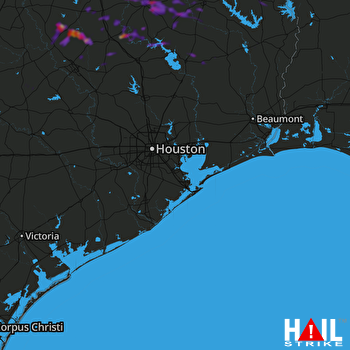 HOUSTON (KHGX) RADAR

