This weather event on September 25, 2025 includes:
2 states
20 counties,
24 cities,
and 58 zip codes.
There were 1971 total properties that were impacted and have possible damage.
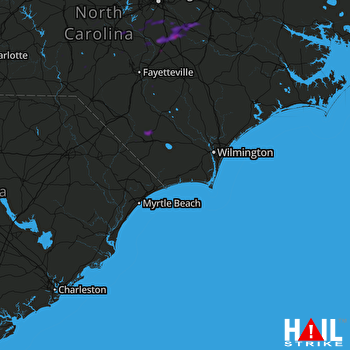 WILMINGTON (KLTX) RADAR
States Impacted By Hail On September 25, 2025
North Carolina
·
South Carolina
Counties Impacted By Hail On September 25, 2025
Bladen, NC
·
Chatham, NC
·
Columbus, NC
·
Cumberland, NC
·
Durham, NC
·
Greene, NC
·
Harnett, NC
·
Johnston, NC
·
Lee, NC
·
Montgomery, NC
·
Moore, NC
·
Richmond, NC
·
Robeson, NC
·
Sampson, NC
·
Wake, NC
·
Wayne, NC
·
Wilson, NC
·
Chesterfield, SC
·
Dillon, SC
·
Horry, SC
Cities Impacted By Hail On September 25, 2025
Angier, NC
·
Benson, NC
·
Broadway, NC
·
Bunnlevel, NC
·
Clarkton, NC
·
Clayton, NC
·
Coats, NC
·
Conway, SC
·
Dunn, NC
·
Evergreen, NC
·
Four Oaks, NC
·
Fuquay-Varina, NC
·
Kenly, NC
·
Lillington, NC
·
Micro, NC
·
Pikeville, NC
·
Pine Level, NC
·
Plain View, NC
·
Red Hill, SC
·
Robbins, NC
·
Sanford, NC
·
Selma, NC
·
Smithfield, NC
·
Wilson's Mills, NC
Zip Codes Impacted By Hail On September 25, 2025
27207
·
27229
·
27242
·
27252
·
27281
·
27306
·
27312
·
27325
·
27330
·
27332
·
27344
·
27356
·
27501
·
27504
·
27505
·
27517
·
27520
·
27521
·
27524
·
27526
·
27527
·
27529
·
27540
·
27542
·
27546
·
27555
·
27559
·
27562
·
27568
·
27569
·
27576
·
27577
·
27592
·
27603
·
27713
·
27830
·
27863
·
27883
·
28312
·
28315
·
28323
·
28326
·
28334
·
28338
·
28339
·
28356
·
28369
·
28431
·
28433
·
28438
·
28472
·
29520
·
29526
·
29527
·
29579
·
29581
·
28320
·
28430

