This weather event on September 12, 2025 includes:
1 states
9 counties,
31 cities,
and 50 zip codes.
There were 2331 total properties that were impacted and have possible damage.
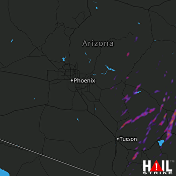 PHOENIX (KIWA) RADAR
States Impacted By Hail On September 12, 2025
Arizona
Counties Impacted By Hail On September 12, 2025
Apache, AZ
·
Cochise, AZ
·
Gila, AZ
·
Graham, AZ
·
Greenlee, AZ
·
Navajo, AZ
·
Pima, AZ
·
Pinal, AZ
·
Santa Cruz, AZ
Cities Impacted By Hail On September 12, 2025
Benson, AZ
·
Bryce, AZ
·
Bylas, AZ
·
Cactus Flats, AZ
·
Campo Bonito, AZ
·
Catalina, AZ
·
Catalina Foothills, AZ
·
Dripping Springs, AZ
·
Dudleyville, AZ
·
East Fork, AZ
·
Elgin, AZ
·
Hayden, AZ
·
Mescal, AZ
·
Oracle, AZ
·
Oro Valley, AZ
·
Peridot, AZ
·
Pima, AZ
·
Pimaco Two, AZ
·
Saddlebrooke, AZ
·
Safford, AZ
·
San Carlos, AZ
·
San Manuel, AZ
·
Sonoita, AZ
·
Superior, AZ
·
Swift Trail Junction, AZ
·
Tanque Verde, AZ
·
Tombstone, AZ
·
Top-of-the-World, AZ
·
Wheatfields, AZ
·
Willcox, AZ
·
Winkelman, AZ
Zip Codes Impacted By Hail On September 12, 2025
85132
·
85135
·
85137
·
85173
·
85501
·
85530
·
85531
·
85533
·
85534
·
85536
·
85539
·
85540
·
85542
·
85543
·
85545
·
85546
·
85551
·
85552
·
85554
·
85602
·
85605
·
85606
·
85609
·
85610
·
85611
·
85616
·
85618
·
85619
·
85623
·
85624
·
85625
·
85627
·
85630
·
85631
·
85637
·
85638
·
85641
·
85643
·
85718
·
85737
·
85739
·
85749
·
85755
·
85911
·
85923
·
85930
·
85933
·
85941
·
85550
·
85192

