This weather event on September 9, 2025 includes:
3 states
23 counties,
18 cities,
and 62 zip codes.
There were 1372 total properties that were impacted and have possible damage.
States Impacted By Hail On September 9, 2025
Iowa
·
Minnesota
·
South Dakota
Counties Impacted By Hail On September 9, 2025
Buena Vista, IA
·
Cherokee, IA
·
Ida, IA
·
Palo Alto, IA
·
Pocahontas, IA
·
Sac, IA
·
Big Stone, MN
·
Chippewa, MN
·
Lac qui Parle, MN
·
Lincoln, MN
·
Lyon, MN
·
Murray, MN
·
Pipestone, MN
·
Redwood, MN
·
Renville, MN
·
Rock, MN
·
Swift, MN
·
Yellow Medicine, MN
·
Brookings, SD
·
Lake, SD
·
McCook, SD
·
Minnehaha, SD
·
Moody, SD
Cities Impacted By Hail On September 9, 2025
Albert City, IA
·
Anderson, SD
·
Appleton, MN
·
Balaton, MN
·
Curlew, IA
·
Florence, MN
·
Galva, IA
·
Hazel Run, MN
·
Louisburg, MN
·
Marshall, MN
·
Meadow View Addition, SD
·
Minneota, MN
·
Odessa, MN
·
Ortonville, MN
·
Porter, MN
·
Renner Corner, SD
·
Sioux Falls, SD
·
Watson, MN
Zip Codes Impacted By Hail On September 9, 2025
50510
·
50527
·
50562
·
50565
·
50568
·
50574
·
50588
·
51002
·
51005
·
51020
·
51025
·
51049
·
51053
·
51445
·
56115
·
56144
·
56164
·
56170
·
56178
·
56208
·
56212
·
56220
·
56222
·
56223
·
56227
·
56229
·
56237
·
56239
·
56241
·
56249
·
56256
·
56258
·
56260
·
56262
·
56263
·
56264
·
56265
·
56276
·
56278
·
56280
·
56291
·
56292
·
56295
·
56297
·
57002
·
57005
·
57020
·
57022
·
57026
·
57028
·
57030
·
57035
·
57048
·
57055
·
57075
·
57104
·
57107
·
57110
·
50554
·
51012
·
57003
·
57065
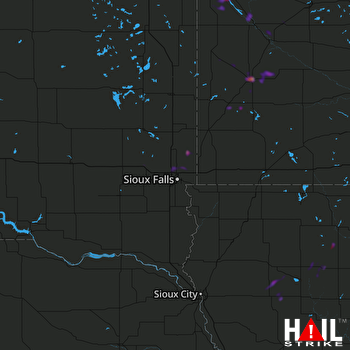 SIOUX FALLS (KFSD) RADAR

