This weather event on August 15, 2025 includes:
3 states
23 counties,
17 cities,
and 77 zip codes.
There were 693 total properties that were impacted and have possible damage.
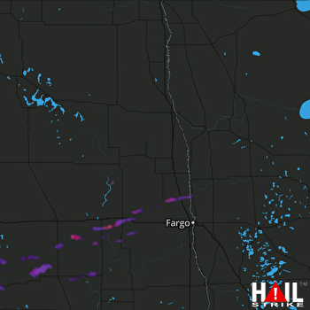 GRAND FORKS (KMVX) RADAR
States Impacted By Hail On August 15, 2025
Minnesota
·
North Dakota
·
South Dakota
Counties Impacted By Hail On August 15, 2025
Big Stone, MN
·
Cass, MN
·
Clay, MN
·
Hubbard, MN
·
Mahnomen, MN
·
Norman, MN
·
Otter Tail, MN
·
Traverse, MN
·
Barnes, ND
·
Cass, ND
·
Dickey, ND
·
Emmons, ND
·
Griggs, ND
·
LaMoure, ND
·
Logan, ND
·
McIntosh, ND
·
Steele, ND
·
Stutsman, ND
·
Brown, SD
·
Day, SD
·
Marshall, SD
·
McPherson, SD
·
Roberts, SD
Cities Impacted By Hail On August 15, 2025
Britton, SD
·
Browns Valley, MN
·
Ellendale, ND
·
Embden, ND
·
Forbes, ND
·
Gardner, ND
·
Hecla, SD
·
Lake City, SD
·
Langford, SD
·
Laporte, MN
·
Long Hollow, SD
·
Oriska, ND
·
Perley, MN
·
Sisseton, SD
·
Tower City, ND
·
Wishek, ND
·
Ypsilanti, ND
Zip Codes Impacted By Hail On August 15, 2025
56211
·
56219
·
56436
·
56461
·
56467
·
56470
·
56528
·
56545
·
56546
·
56557
·
56574
·
56576
·
56584
·
56589
·
57232
·
57247
·
57262
·
57270
·
57401
·
57421
·
57422
·
57427
·
57430
·
57432
·
57433
·
57437
·
57441
·
57446
·
57449
·
57454
·
57456
·
57457
·
57481
·
58004
·
58006
·
58007
·
58011
·
58029
·
58031
·
58036
·
58046
·
58048
·
58049
·
58056
·
58062
·
58063
·
58071
·
58072
·
58079
·
58230
·
58401
·
58413
·
58415
·
58433
·
58436
·
58439
·
58440
·
58442
·
58454
·
58456
·
58458
·
58460
·
58461
·
58466
·
58472
·
58474
·
58480
·
58481
·
58483
·
58490
·
58495
·
58497
·
58524
·
58549
·
58561
·
58005
·
57445

