This weather event on July 18, 2025 includes:
1 states
17 counties,
17 cities,
and 67 zip codes.
There were 68 total properties that were impacted and have possible damage.
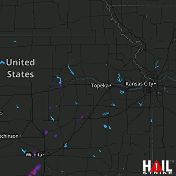 TOPEKA (KTWX) RADAR
States Impacted By Hail On July 18, 2025
Kansas
Counties Impacted By Hail On July 18, 2025
Butler, KS
·
Chase, KS
·
Clay, KS
·
Dickinson, KS
·
Geary, KS
·
Harvey, KS
·
Lyon, KS
·
Marion, KS
·
McPherson, KS
·
Morris, KS
·
Osage, KS
·
Ottawa, KS
·
Rice, KS
·
Riley, KS
·
Saline, KS
·
Sedgwick, KS
·
Sumner, KS
Cities Impacted By Hail On July 18, 2025
Admire, KS
·
Americus, KS
·
Clearwater, KS
·
Colwich, KS
·
Conway Springs, KS
·
Cottonwood Falls, KS
·
Goddard, KS
·
Grandview Plaza, KS
·
Gypsum, KS
·
Hillsboro, KS
·
Junction City, KS
·
Kechi, KS
·
Park City, KS
·
Strong City, KS
·
Valley Center, KS
·
Walton, KS
·
Wichita, KS
Zip Codes Impacted By Hail On July 18, 2025
66413
·
66441
·
66442
·
66514
·
66523
·
66801
·
66830
·
66833
·
66835
·
66840
·
66845
·
66846
·
66865
·
66866
·
66868
·
66869
·
66872
·
66873
·
67001
·
67004
·
67020
·
67026
·
67030
·
67031
·
67050
·
67052
·
67056
·
67060
·
67063
·
67073
·
67103
·
67105
·
67114
·
67120
·
67135
·
67147
·
67151
·
67152
·
67154
·
67204
·
67205
·
67209
·
67212
·
67215
·
67219
·
67223
·
67227
·
67235
·
67401
·
67410
·
67425
·
67431
·
67432
·
67438
·
67443
·
67444
·
67448
·
67449
·
67451
·
67460
·
67480
·
67483
·
67484
·
67487
·
67554
·
67203
·
67108

