This weather event on July 14, 2025 includes:
2 states
21 counties,
16 cities,
and 88 zip codes.
There were 7431 total properties that were impacted and have possible damage.
States Impacted By Hail On July 14, 2025
Louisiana
·
Texas
Counties Impacted By Hail On July 14, 2025
Calcasieu, LA
·
Cameron, LA
·
Jefferson Davis, LA
·
Angelina, TX
·
Bastrop, TX
·
Brazos, TX
·
Burleson, TX
·
Fayette, TX
·
Gonzales, TX
·
Grimes, TX
·
Harris, TX
·
Houston, TX
·
Lee, TX
·
Milam, TX
·
Montgomery, TX
·
Nacogdoches, TX
·
Newton, TX
·
San Augustine, TX
·
San Jacinto, TX
·
Trinity, TX
·
Washington, TX
Cities Impacted By Hail On July 14, 2025
Bryan, TX
·
Circle D-KC Estates, TX
·
College Station, TX
·
Conroe, TX
·
Crockett, TX
·
Cut and Shoot, TX
·
Deer Park, TX
·
Hudson, TX
·
La Porte, TX
·
Lufkin, TX
·
Pasadena, TX
·
Smithville, TX
·
South Houston, TX
·
Spring, TX
·
The Woodlands, TX
·
Tomball, TX
Zip Codes Impacted By Hail On July 14, 2025
70549
·
70630
·
70646
·
75835
·
75845
·
75847
·
75851
·
75856
·
75901
·
75904
·
75929
·
75944
·
75949
·
75964
·
75969
·
75977
·
75980
·
76567
·
76577
·
77013
·
77014
·
77015
·
77018
·
77034
·
77037
·
77038
·
77060
·
77067
·
77068
·
77069
·
77073
·
77090
·
77091
·
77092
·
77301
·
77302
·
77303
·
77304
·
77306
·
77316
·
77328
·
77354
·
77373
·
77375
·
77377
·
77379
·
77380
·
77381
·
77382
·
77384
·
77385
·
77386
·
77388
·
77389
·
77433
·
77505
·
77506
·
77507
·
77536
·
77571
·
77587
·
77807
·
77831
·
77835
·
77836
·
77840
·
77845
·
77857
·
77861
·
77878
·
77879
·
78650
·
78659
·
78932
·
78941
·
78946
·
78947
·
78949
·
78953
·
78957
·
78959
·
78963
·
78602
·
77830
·
77493
·
77008
·
75926
·
70647
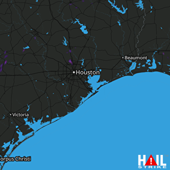 HOUSTON (KHGX) RADAR

