This weather event on June 22, 2025 includes:
2 states
19 counties,
17 cities,
and 57 zip codes.
There were total properties that were impacted and have possible damage.
States Impacted By Hail On June 22, 2025
Nebraska
·
South Dakota
Counties Impacted By Hail On June 22, 2025
Antelope, NE
·
Boone, NE
·
Boyd, NE
·
Garfield, NE
·
Greeley, NE
·
Hamilton, NE
·
Holt, NE
·
Knox, NE
·
Nance, NE
·
Pierce, NE
·
Sherman, NE
·
Valley, NE
·
Wheeler, NE
·
Bon Homme, SD
·
Charles Mix, SD
·
Hutchinson, SD
·
Lincoln, SD
·
Turner, SD
·
Yankton, SD
Cities Impacted By Hail On June 22, 2025
Arcadia, NE
·
Bartlett, NE
·
Chambers, NE
·
Elyria, NE
·
Ericson, NE
·
Inman, NE
·
Monowi, NE
·
Niobrara, NE
·
O'Neill, NE
·
Ord, NE
·
Running Water, SD
·
Santee, NE
·
Scotland, SD
·
Springfield, SD
·
Tabor, SD
·
Tyndall, SD
·
Verdel, NE
Zip Codes Impacted By Hail On June 22, 2025
57014
·
57021
·
57029
·
57037
·
57039
·
57040
·
57043
·
57045
·
57059
·
57062
·
57063
·
57066
·
57067
·
57078
·
57315
·
57329
·
57380
·
68620
·
68622
·
68636
·
68637
·
68638
·
68660
·
68665
·
68711
·
68718
·
68724
·
68725
·
68726
·
68729
·
68734
·
68735
·
68756
·
68760
·
68763
·
68764
·
68766
·
68769
·
68773
·
68783
·
68786
·
68789
·
68815
·
68818
·
68823
·
68828
·
68837
·
68842
·
68852
·
68853
·
68859
·
68862
·
68871
·
68875
·
68730
·
68742
·
68746
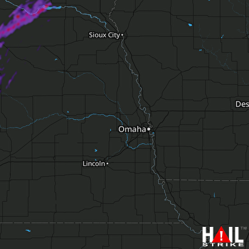 OMAHA (KOAX) RADAR

