This weather event on May 25, 2025 includes:
3 states
23 counties,
16 cities,
and 62 zip codes.
There were 363 total properties that were impacted and have possible damage.
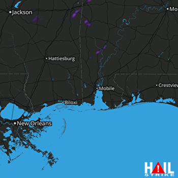 MOBILE (KMOB) RADAR
States Impacted By Hail On May 25, 2025
Alabama
·
Florida
·
Mississippi
Counties Impacted By Hail On May 25, 2025
Baldwin, AL
·
Choctaw, AL
·
Clarke, AL
·
Greene, AL
·
Marengo, AL
·
Sumter, AL
·
Washington, AL
·
Wilcox, AL
·
Santa Rosa, FL
·
Clarke, MS
·
Forrest, MS
·
Greene, MS
·
Jasper, MS
·
Jefferson Davis, MS
·
Jones, MS
·
Kemper, MS
·
Lauderdale, MS
·
Marion, MS
·
Newton, MS
·
Rankin, MS
·
Scott, MS
·
Smith, MS
·
Wayne, MS
Cities Impacted By Hail On May 25, 2025
Butler, AL
·
Enterprise, MS
·
Jackson, AL
·
Leroy, AL
·
Lisman, AL
·
Livingston, AL
·
Louin, MS
·
Loxley, AL
·
Marion, MS
·
Meridian, MS
·
Morton, MS
·
Pine Level, FL
·
Polkville, MS
·
Stonewall, MS
·
Toomsuba, MS
·
York, AL
Zip Codes Impacted By Hail On May 25, 2025
32565
·
35443
·
35459
·
35470
·
36451
·
36539
·
36545
·
36551
·
36567
·
36569
·
36579
·
36583
·
36585
·
36727
·
36769
·
36784
·
36904
·
36907
·
36908
·
36912
·
36921
·
36925
·
39042
·
39074
·
39092
·
39117
·
39145
·
39152
·
39153
·
39168
·
39301
·
39305
·
39307
·
39323
·
39330
·
39332
·
39335
·
39336
·
39337
·
39338
·
39342
·
39347
·
39348
·
39352
·
39355
·
39356
·
39360
·
39363
·
39364
·
39366
·
39422
·
39427
·
39429
·
39439
·
39451
·
39452
·
39456
·
39465
·
39480
·
36548
·
36728
·
39421

