This weather event on May 18, 2025 includes:
4 states
56 counties,
65 cities,
and 203 zip codes.
There were 5341 total properties that were impacted and have possible damage.
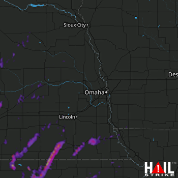 OMAHA (KOAX) RADAR
States Impacted By Hail On May 18, 2025
Iowa
·
Kansas
·
Missouri
·
Nebraska
Counties Impacted By Hail On May 18, 2025
Fremont, IA
·
Brown, KS
·
Clay, KS
·
Cloud, KS
·
Jewell, KS
·
Marshall, KS
·
Nemaha, KS
·
Pottawatomie, KS
·
Republic, KS
·
Riley, KS
·
Washington, KS
·
Atchison, MO
·
Adams, NE
·
Antelope, NE
·
Boone, NE
·
Buffalo, NE
·
Butler, NE
·
Clay, NE
·
Colfax, NE
·
Cuming, NE
·
Dodge, NE
·
Douglas, NE
·
Fillmore, NE
·
Gage, NE
·
Garfield, NE
·
Greeley, NE
·
Hall, NE
·
Hamilton, NE
·
Holt, NE
·
Howard, NE
·
Jefferson, NE
·
Johnson, NE
·
Kearney, NE
·
Lancaster, NE
·
Madison, NE
·
Merrick, NE
·
Nance, NE
·
Nemaha, NE
·
Nuckolls, NE
·
Otoe, NE
·
Pawnee, NE
·
Pierce, NE
·
Platte, NE
·
Polk, NE
·
Richardson, NE
·
Saline, NE
·
Saunders, NE
·
Seward, NE
·
Sherman, NE
·
Stanton, NE
·
Thayer, NE
·
Valley, NE
·
Washington, NE
·
Webster, NE
·
Wheeler, NE
·
York, NE
Cities Impacted By Hail On May 18, 2025
Archer, NE
·
Ashton, NE
·
Auburn, NE
·
Aurora, NE
·
Bartlett, NE
·
Beatrice, NE
·
Belleville, KS
·
Blue Hill, NE
·
Blue Springs, NE
·
Brownville, NE
·
Burr Oak, KS
·
Cairo, NE
·
Central City, NE
·
Centralia, KS
·
Clarkson, NE
·
Columbus, NE
·
Concordia, KS
·
Cordova, NE
·
Creston, NE
·
Crete, NE
·
Cuba, KS
·
Dannebrog, NE
·
Davenport, NE
·
Duncan, NE
·
Exeter, NE
·
Fairbury, NE
·
Fairmont, NE
·
Filley, NE
·
Formoso, KS
·
Geneva, NE
·
Genoa, NE
·
Gibbon, NE
·
Grand Island, NE
·
Holmesville, NE
·
Jamestown, KS
·
Johnson, NE
·
Leonardville, KS
·
Lincoln, NE
·
Mahaska, KS
·
Mankato, KS
·
Milford, NE
·
Milligan, NE
·
Minden, NE
·
Monroe, NE
·
Narka, KS
·
Nelson, NE
·
Nora, NE
·
North Loup, NE
·
Ong, NE
·
Ord, NE
·
Plymouth, NE
·
Randall, KS
·
Randolph, KS
·
Reynolds, NE
·
Sabetha, KS
·
Scandia, KS
·
Schuyler, NE
·
Shickley, NE
·
St. Paul, NE
·
Stromsburg, NE
·
Tecumseh, NE
·
Vermillion, KS
·
Virginia, NE
·
Watson, MO
·
Wymore, NE
Zip Codes Impacted By Hail On May 18, 2025
51601
·
51639
·
51640
·
51650
·
64482
·
64496
·
66404
·
66411
·
66415
·
66425
·
66427
·
66434
·
66449
·
66503
·
66515
·
66520
·
66527
·
66531
·
66534
·
66544
·
66549
·
66554
·
66901
·
66930
·
66935
·
66936
·
66938
·
66939
·
66940
·
66941
·
66942
·
66944
·
66948
·
66949
·
66955
·
66956
·
66959
·
66960
·
66963
·
66964
·
66966
·
67432
·
67447
·
68002
·
68018
·
68025
·
68044
·
68064
·
68301
·
68305
·
68310
·
68313
·
68318
·
68320
·
68321
·
68326
·
68329
·
68332
·
68333
·
68335
·
68336
·
68338
·
68340
·
68341
·
68342
·
68343
·
68345
·
68348
·
68351
·
68352
·
68354
·
68357
·
68359
·
68361
·
68365
·
68368
·
68370
·
68375
·
68376
·
68377
·
68378
·
68404
·
68405
·
68406
·
68415
·
68421
·
68423
·
68424
·
68433
·
68434
·
68436
·
68441
·
68443
·
68444
·
68445
·
68450
·
68452
·
68453
·
68454
·
68456
·
68458
·
68460
·
68464
·
68465
·
68466
·
68467
·
68514
·
68522
·
68523
·
68601
·
68620
·
68622
·
68624
·
68627
·
68629
·
68631
·
68632
·
68633
·
68634
·
68636
·
68637
·
68638
·
68640
·
68642
·
68643
·
68647
·
68651
·
68652
·
68653
·
68654
·
68661
·
68663
·
68665
·
68666
·
68669
·
68720
·
68725
·
68726
·
68729
·
68735
·
68748
·
68756
·
68761
·
68769
·
68779
·
68791
·
68801
·
68803
·
68815
·
68816
·
68817
·
68818
·
68820
·
68823
·
68824
·
68826
·
68827
·
68831
·
68832
·
68838
·
68840
·
68841
·
68847
·
68852
·
68853
·
68854
·
68862
·
68864
·
68869
·
68871
·
68873
·
68875
·
68876
·
68883
·
68925
·
68930
·
68933
·
68935
·
68938
·
68941
·
68942
·
68944
·
68945
·
68956
·
68957
·
68959
·
68961
·
68964
·
68970
·
68974
·
68975
·
68978
·
68979
·
68859
·
68835
·
68641
·
68628
·
68517
·
68355
·
68339
·
68324
·
66538
·
51648

