This weather event on May 14, 2025 includes:
3 states
22 counties,
26 cities,
and 83 zip codes.
There were total properties that were impacted and have possible damage.
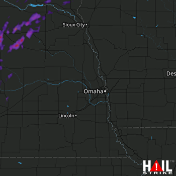 OMAHA (KOAX) RADAR
States Impacted By Hail On May 14, 2025
Iowa
·
Nebraska
·
South Dakota
Counties Impacted By Hail On May 14, 2025
Sioux, IA
·
Antelope, NE
·
Boone, NE
·
Boyd, NE
·
Cedar, NE
·
Garfield, NE
·
Greeley, NE
·
Hall, NE
·
Holt, NE
·
Howard, NE
·
Knox, NE
·
Pierce, NE
·
Sherman, NE
·
Valley, NE
·
Wheeler, NE
·
Bon Homme, SD
·
Charles Mix, SD
·
Clay, SD
·
Lincoln, SD
·
Turner, SD
·
Union, SD
·
Yankton, SD
Cities Impacted By Hail On May 14, 2025
Arcadia, NE
·
Bartlett, NE
·
Bazile Mills, NE
·
Bloomfield, NE
·
Brunswick, NE
·
Chambers, NE
·
Clearwater, NE
·
Cotesfield, NE
·
Elyria, NE
·
Ericson, NE
·
Farwell, NE
·
Fordyce, NE
·
Hudson, SD
·
Hurley, SD
·
Inman, NE
·
Litchfield, NE
·
Neligh, NE
·
North Loup, NE
·
O'Neill, NE
·
Ord, NE
·
Osmond, NE
·
Plainview, NE
·
Scotia, NE
·
Tyndall, SD
·
Wausa, NE
·
Yankton, SD
Zip Codes Impacted By Hail On May 14, 2025
51023
·
57001
·
57004
·
57010
·
57014
·
57029
·
57031
·
57034
·
57036
·
57037
·
57043
·
57045
·
57053
·
57059
·
57062
·
57066
·
57067
·
57069
·
57070
·
57072
·
57073
·
57078
·
57315
·
57329
·
57380
·
68620
·
68622
·
68627
·
68636
·
68637
·
68655
·
68665
·
68711
·
68718
·
68720
·
68724
·
68725
·
68726
·
68729
·
68730
·
68735
·
68736
·
68739
·
68742
·
68746
·
68747
·
68756
·
68760
·
68763
·
68764
·
68765
·
68766
·
68769
·
68773
·
68774
·
68783
·
68786
·
68789
·
68792
·
68803
·
68815
·
68817
·
68820
·
68823
·
68828
·
68831
·
68835
·
68837
·
68838
·
68842
·
68844
·
68852
·
68853
·
68859
·
68862
·
68864
·
68872
·
68873
·
68875
·
68882
·
57021
·
57046
·
68761

