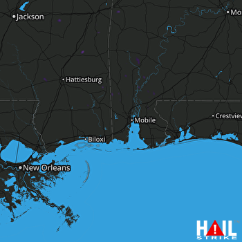
This weather event on May 11, 2025 includes:
3 states
24 counties,
13 cities,
and 52 zip codes.
There were 1778 total properties that were impacted and have possible damage.
States Impacted By Hail On May 11, 2025
Alabama
·
Florida
·
Mississippi
Counties Impacted By Hail On May 11, 2025
Baldwin, AL
·
Choctaw, AL
·
Clarke, AL
·
Escambia, AL
·
Marengo, AL
·
Mobile, AL
·
Monroe, AL
·
Sumter, AL
·
Washington, AL
·
Escambia, FL
·
St. Bernard, LA
·
Clarke, MS
·
George, MS
·
Greene, MS
·
Jackson, MS
·
Jasper, MS
·
Jones, MS
·
Lamar, MS
·
Marion, MS
·
Newton, MS
·
Perry, MS
·
Scott, MS
·
Smith, MS
·
Wayne, MS
Cities Impacted By Hail On May 11, 2025
Atmore, AL
·
Bay Minette, AL
·
Carlton, AL
·
Citronelle, AL
·
Coffeeville, AL
·
Gulfcrest, AL
·
Hobson, AL
·
Jackson, AL
·
Mobile, AL
·
Rockville, AL
·
Semmes, AL
·
Sims Chapel, AL
·
Stockton, AL
Zip Codes Impacted By Hail On May 11, 2025
32568
·
36480
·
36502
·
36507
·
36518
·
36521
·
36522
·
36524
·
36545
·
36550
·
36553
·
36556
·
36558
·
36560
·
36562
·
36569
·
36575
·
36579
·
36583
·
36584
·
36585
·
36587
·
36608
·
36618
·
36695
·
36727
·
36736
·
36782
·
36907
·
36908
·
36921
·
36922
·
39074
·
39092
·
39301
·
39336
·
39338
·
39348
·
39355
·
39360
·
39422
·
39423
·
39425
·
39429
·
39439
·
39443
·
39451
·
39452
·
39456
·
39476
·
39482
·
39562
 MOBILE (KMOB) RADAR

