This weather event on April 24, 2025 includes:
4 states
44 counties,
56 cities,
and 207 zip codes.
There were 57357 total properties that were impacted and have possible damage.
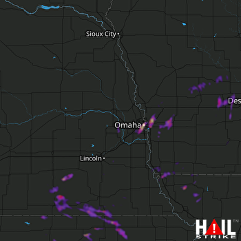 OMAHA (KOAX) RADAR
States Impacted By Hail On April 24, 2025
Iowa
·
Kansas
·
Missouri
·
Nebraska
Counties Impacted By Hail On April 24, 2025
Adair, IA
·
Audubon, IA
·
Carroll, IA
·
Dallas, IA
·
Fremont, IA
·
Greene, IA
·
Guthrie, IA
·
Harrison, IA
·
Mills, IA
·
Monona, IA
·
Montgomery, IA
·
Page, IA
·
Pottawattamie, IA
·
Shelby, IA
·
Union, IA
·
Clay, KS
·
Cloud, KS
·
Marshall, KS
·
Pottawatomie, KS
·
Republic, KS
·
Riley, KS
·
Washington, KS
·
Atchison, MO
·
Nodaway, MO
·
Burt, NE
·
Butler, NE
·
Cass, NE
·
Dodge, NE
·
Douglas, NE
·
Fillmore, NE
·
Gage, NE
·
Jefferson, NE
·
Johnson, NE
·
Lancaster, NE
·
Nemaha, NE
·
Nuckolls, NE
·
Otoe, NE
·
Pawnee, NE
·
Saline, NE
·
Sarpy, NE
·
Saunders, NE
·
Seward, NE
·
Thayer, NE
·
Washington, NE
Cities Impacted By Hail On April 24, 2025
Alexandria, NE
·
Ashland, NE
·
Audubon, IA
·
Barneston, NE
·
Bayard, IA
·
Beattie, KS
·
Bellevue, NE
·
Belvidere, NE
·
Bennington, NE
·
Blue Springs, NE
·
Braddyville, IA
·
Burchard, NE
·
Burlington Junction, MO
·
Byron, NE
·
Carson, IA
·
Carter Lake, IA
·
Casey, IA
·
Chalco, NE
·
Coin, IA
·
Council Bluffs, IA
·
Diller, NE
·
Endicott, NE
·
Fairbury, NE
·
Farragut, IA
·
Gilead, NE
·
Green, KS
·
Greenleaf, KS
·
Hancock, IA
·
Hebron, NE
·
Home, KS
·
King Lake, NE
·
La Vista, NE
·
Leonardville, KS
·
Linden, IA
·
Marysville, KS
·
Milligan, NE
·
Mineola, IA
·
Oakland, IA
·
Oketo, KS
·
Omaha, NE
·
Papillion, NE
·
Persia, IA
·
Peru, NE
·
Ralston, NE
·
Randolph, KS
·
Richfield, NE
·
Shenandoah, IA
·
Skidmore, MO
·
Strang, NE
·
Stuart, IA
·
Treynor, IA
·
Vermillion, KS
·
Walnut, IA
·
Weston, IA
·
Wymore, NE
·
Yutan, NE
Zip Codes Impacted By Hail On April 24, 2025
50002
·
50003
·
50025
·
50026
·
50029
·
50048
·
50058
·
50070
·
50076
·
50115
·
50129
·
50146
·
50164
·
50216
·
50233
·
50250
·
50801
·
50846
·
50849
·
50851
·
51040
·
51446
·
51447
·
51454
·
51455
·
51462
·
51501
·
51503
·
51510
·
51521
·
51525
·
51526
·
51531
·
51533
·
51534
·
51536
·
51537
·
51542
·
51543
·
51548
·
51549
·
51553
·
51554
·
51559
·
51560
·
51561
·
51571
·
51575
·
51576
·
51577
·
51601
·
51630
·
51631
·
51636
·
51639
·
51640
·
51647
·
51648
·
51649
·
51650
·
51652
·
51654
·
64423
·
64428
·
64431
·
64445
·
64446
·
64455
·
64468
·
64482
·
64487
·
64491
·
64496
·
64498
·
66403
·
66406
·
66412
·
66427
·
66432
·
66438
·
66449
·
66503
·
66508
·
66518
·
66520
·
66521
·
66544
·
66548
·
66554
·
66930
·
66933
·
66935
·
66937
·
66938
·
66943
·
66945
·
66946
·
66953
·
66962
·
66964
·
66966
·
66968
·
67432
·
67447
·
68002
·
68005
·
68007
·
68020
·
68022
·
68025
·
68028
·
68029
·
68033
·
68034
·
68041
·
68042
·
68046
·
68059
·
68061
·
68064
·
68069
·
68073
·
68102
·
68104
·
68105
·
68106
·
68107
·
68108
·
68110
·
68111
·
68114
·
68116
·
68117
·
68118
·
68123
·
68124
·
68127
·
68128
·
68131
·
68132
·
68133
·
68137
·
68138
·
68144
·
68147
·
68154
·
68157
·
68178
·
68303
·
68305
·
68310
·
68315
·
68318
·
68322
·
68323
·
68325
·
68326
·
68332
·
68335
·
68338
·
68339
·
68342
·
68350
·
68351
·
68352
·
68354
·
68358
·
68359
·
68361
·
68362
·
68366
·
68370
·
68372
·
68375
·
68377
·
68381
·
68404
·
68406
·
68407
·
68410
·
68415
·
68416
·
68421
·
68423
·
68436
·
68440
·
68441
·
68444
·
68450
·
68453
·
68461
·
68466
·
68520
·
68527
·
68528
·
68532
·
68632
·
68943
·
51563
·
51632
·
66901
·
66955
·
68003
·
68135
·
68309
·
68327
·
68524

