This weather event on April 22, 2025 includes:
3 states
15 counties,
25 cities,
and 63 zip codes.
There were 2303 total properties that were impacted and have possible damage.
States Impacted By Hail On April 22, 2025
Iowa
·
Kansas
·
Nebraska
Counties Impacted By Hail On April 22, 2025
Calhoun, IA
·
Carroll, IA
·
Crawford, IA
·
Decatur, IA
·
Greene, IA
·
Ida, IA
·
Monona, IA
·
Pocahontas, IA
·
Ringgold, IA
·
Sac, IA
·
Webster, IA
·
Woodbury, IA
·
Atchison, KS
·
Doniphan, KS
·
Thurston, NE
Cities Impacted By Hail On April 22, 2025
Anthon, IA
·
Barnum, IA
·
Climbing Hill, IA
·
Cushing, IA
·
Decatur City, IA
·
Hornick, IA
·
Ida Grove, IA
·
Kellerton, IA
·
Lake City, IA
·
Lake View, IA
·
Leon, IA
·
Lytton, IA
·
Mount Ayr, IA
·
Odebolt, IA
·
Oto, IA
·
Ralston, IA
·
Rinard, IA
·
Rockwell City, IA
·
Sac City, IA
·
Sloan, IA
·
Smithland, IA
·
Somers, IA
·
Troy, KS
·
Twin Lakes, IA
·
Wall Lake, IA
Zip Codes Impacted By Hail On April 22, 2025
50050
·
50067
·
50103
·
50108
·
50133
·
50140
·
50144
·
50501
·
50518
·
50524
·
50535
·
50538
·
50540
·
50551
·
50561
·
50563
·
50575
·
50579
·
50583
·
50586
·
50854
·
51004
·
51006
·
51016
·
51018
·
51019
·
51020
·
51026
·
51034
·
51039
·
51044
·
51052
·
51053
·
51055
·
51061
·
51063
·
51431
·
51433
·
51436
·
51441
·
51442
·
51443
·
51445
·
51449
·
51450
·
51453
·
51458
·
51459
·
51462
·
51465
·
51466
·
66016
·
66023
·
66041
·
66060
·
66087
·
66090
·
68062
·
68067
·
68071
·
51448
·
51056
·
51025
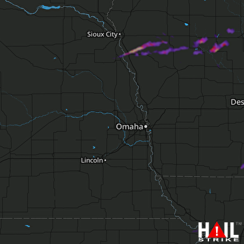 OMAHA (KOAX) RADAR

