This weather event on April 22, 2025 includes:
1 states
35 counties,
16 cities,
and 70 zip codes.
There were 7663 total properties that were impacted and have possible damage.
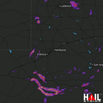 MIDLAND/ODSSA (KMAF) RADAR
States Impacted By Hail On April 22, 2025
Texas
Counties Impacted By Hail On April 22, 2025
Andrews, TX
·
Brewster, TX
·
Cochran, TX
·
Coke, TX
·
Crockett, TX
·
Crosby, TX
·
Dickens, TX
·
Ector, TX
·
Fisher, TX
·
Floyd, TX
·
Gaines, TX
·
Hale, TX
·
Hockley, TX
·
Irion, TX
·
Kent, TX
·
King, TX
·
Lamb, TX
·
Lubbock, TX
·
Lynn, TX
·
Nolan, TX
·
Pecos, TX
·
Reagan, TX
·
Reeves, TX
·
Runnels, TX
·
Schleicher, TX
·
Scurry, TX
·
Stonewall, TX
·
Sutton, TX
·
Taylor, TX
·
Terrell, TX
·
Terry, TX
·
Tom Green, TX
·
Val Verde, TX
·
Winkler, TX
·
Yoakum, TX
Cities Impacted By Hail On April 22, 2025
Amherst, TX
·
Big Lake, TX
·
Crosbyton, TX
·
Denver City, TX
·
Eldorado, TX
·
Fort Stockton, TX
·
Kermit, TX
·
Lawn, TX
·
Littlefield, TX
·
Petersburg, TX
·
Plains, TX
·
Ralls, TX
·
Sanderson, TX
·
Sonora, TX
·
Spade, TX
·
Wink, TX
Zip Codes Impacted By Hail On April 22, 2025
76904
·
76905
·
76930
·
76932
·
76933
·
76935
·
76936
·
76941
·
76950
·
76953
·
76955
·
79041
·
79064
·
79072
·
79220
·
79235
·
79236
·
79243
·
79250
·
79311
·
79312
·
79313
·
79322
·
79323
·
79326
·
79336
·
79339
·
79346
·
79355
·
79356
·
79357
·
79359
·
79360
·
79369
·
79370
·
79371
·
79373
·
79376
·
79380
·
79502
·
79506
·
79518
·
79526
·
79528
·
79530
·
79535
·
79536
·
79541
·
79545
·
79562
·
79566
·
79602
·
79714
·
79730
·
79735
·
79741
·
79743
·
79744
·
79745
·
79759
·
79781
·
79785
·
79789
·
79830
·
79848
·
79942
·
76943
·
79229
·
79567
·
79772

