This weather event on April 20, 2025 includes:
1 states
27 counties,
20 cities,
and 73 zip codes.
There were 978 total properties that were impacted and have possible damage.
States Impacted By Hail On April 20, 2025
Texas
Counties Impacted By Hail On April 20, 2025
Bandera, TX
·
Bastrop, TX
·
Bexar, TX
·
Comal, TX
·
Concho, TX
·
Coryell, TX
·
Edwards, TX
·
Gillespie, TX
·
Guadalupe, TX
·
Hamilton, TX
·
Kendall, TX
·
Kerr, TX
·
Kimble, TX
·
Lampasas, TX
·
Lee, TX
·
Llano, TX
·
Mason, TX
·
McCulloch, TX
·
Medina, TX
·
Menard, TX
·
Mills, TX
·
Real, TX
·
San Saba, TX
·
Schleicher, TX
·
Sutton, TX
·
Uvalde, TX
·
Zavala, TX
Cities Impacted By Hail On April 20, 2025
Bandera, TX
·
Boerne, TX
·
Brady, TX
·
Cibolo, TX
·
Cross Mountain, TX
·
Devine, TX
·
Fair Oaks Ranch, TX
·
Fredericksburg, TX
·
Goldthwaite, TX
·
Harper, TX
·
Kerrville, TX
·
Kirby, TX
·
Lake Dunlap, TX
·
Lakehills, TX
·
Lake Medina Shores, TX
·
McQueeney, TX
·
Melvin, TX
·
New Braunfels, TX
·
Rocksprings, TX
·
Scenic Oaks, TX
Zip Codes Impacted By Hail On April 20, 2025
76525
·
76538
·
76566
·
76825
·
76837
·
76841
·
76842
·
76844
·
76848
·
76849
·
76852
·
76853
·
76854
·
76856
·
76858
·
76859
·
76869
·
76872
·
76874
·
76877
·
76885
·
76887
·
76936
·
76950
·
78003
·
78006
·
78010
·
78013
·
78015
·
78016
·
78023
·
78024
·
78028
·
78055
·
78056
·
78058
·
78063
·
78066
·
78109
·
78123
·
78124
·
78130
·
78132
·
78155
·
78219
·
78224
·
78228
·
78238
·
78239
·
78244
·
78255
·
78256
·
78257
·
78258
·
78260
·
78264
·
78624
·
78631
·
78659
·
78839
·
78861
·
78870
·
78872
·
78873
·
78880
·
78885
·
78886
·
78947
·
78948
·
78957
·
78221
·
78108
·
76550
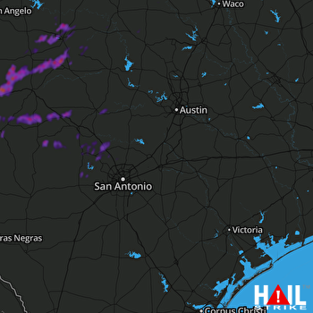 SAN ANTONIO (KEWX) RADAR

