This weather event on April 14, 2025 includes:
3 states
20 counties,
17 cities,
and 97 zip codes.
There were 920 total properties that were impacted and have possible damage.
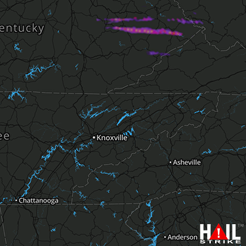 KNOXVILLE (KMRX) RADAR
States Impacted By Hail On April 14, 2025
Kentucky
·
Virginia
·
West Virginia
Counties Impacted By Hail On April 14, 2025
Breathitt, KY
·
Estill, KY
·
Floyd, KY
·
Johnson, KY
·
Knott, KY
·
Laurel, KY
·
Lawrence, KY
·
Lee, KY
·
Letcher, KY
·
Magoffin, KY
·
Martin, KY
·
Morgan, KY
·
Owsley, KY
·
Pike, KY
·
Wolfe, KY
·
Buchanan, VA
·
Dickenson, VA
·
Wise, VA
·
Logan, WV
·
Mingo, WV
Cities Impacted By Hail On April 14, 2025
Beattyville, KY
·
Belfry, KY
·
Coal Run Village, KY
·
Fleming-Neon, KY
·
Jackson, KY
·
Jenkins, KY
·
Matewan, WV
·
McCarr, KY
·
McDowell, KY
·
McRoberts, KY
·
Payne Gap, KY
·
Pikeville, KY
·
Prestonsburg, KY
·
Red Jacket, WV
·
South Williamson, KY
·
Wayland, KY
·
Williamson, WV
Zip Codes Impacted By Hail On April 14, 2025
24228
·
24279
·
24603
·
24614
·
24620
·
25621
·
25638
·
25651
·
25652
·
25661
·
25670
·
25672
·
25678
·
25688
·
25692
·
40336
·
40472
·
40741
·
40744
·
41230
·
41232
·
41238
·
41240
·
41250
·
41264
·
41301
·
41311
·
41314
·
41317
·
41339
·
41348
·
41365
·
41385
·
41397
·
41464
·
41465
·
41472
·
41501
·
41503
·
41514
·
41517
·
41519
·
41526
·
41527
·
41531
·
41535
·
41537
·
41539
·
41540
·
41544
·
41548
·
41553
·
41554
·
41557
·
41562
·
41564
·
41566
·
41567
·
41571
·
41603
·
41607
·
41615
·
41616
·
41619
·
41622
·
41630
·
41631
·
41632
·
41635
·
41640
·
41643
·
41645
·
41647
·
41649
·
41653
·
41655
·
41660
·
41666
·
41772
·
41804
·
41810
·
41815
·
41824
·
41825
·
41826
·
41832
·
41835
·
41836
·
41837
·
41838
·
41839
·
41840
·
41845
·
41847
·
41849
·
41855
·
41858

