This weather event on April 5, 2025 includes:
2 states
11 counties,
13 cities,
and 71 zip codes.
There were total properties that were impacted and have possible damage.
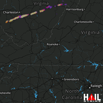 ROANOKE (KFCX) RADAR
States Impacted By Hail On April 5, 2025
Virginia
·
West Virginia
Counties Impacted By Hail On April 5, 2025
Bath, VA
·
Boone, WV
·
Clay, WV
·
Kanawha, WV
·
Lincoln, WV
·
Nicholas, WV
·
Pendleton, WV
·
Pocahontas, WV
·
Randolph, WV
·
Wayne, WV
·
Webster, WV
Cities Impacted By Hail On April 5, 2025
Belle, WV
·
Bergoo, WV
·
Cedar Grove, WV
·
Chelyan, WV
·
Chesapeake, WV
·
Cowen, WV
·
East Bank, WV
·
Glasgow, WV
·
Harts, WV
·
Marmet, WV
·
Rand, WV
·
Shrewsbury, WV
·
Tioga, WV
Zip Codes Impacted By Hail On April 5, 2025
24445
·
24484
·
24920
·
24927
·
24934
·
24944
·
24954
·
25003
·
25009
·
25015
·
25019
·
25024
·
25025
·
25035
·
25039
·
25043
·
25045
·
25051
·
25053
·
25061
·
25067
·
25081
·
25086
·
25107
·
25110
·
25111
·
25125
·
25132
·
25134
·
25142
·
25160
·
25165
·
25169
·
25214
·
25304
·
25306
·
25314
·
25315
·
25501
·
25506
·
25511
·
25524
·
25529
·
25534
·
25557
·
25564
·
25565
·
25567
·
26203
·
26205
·
26206
·
26208
·
26217
·
26222
·
26230
·
26253
·
26264
·
26268
·
26273
·
26282
·
26288
·
26294
·
26298
·
26610
·
26651
·
26656
·
26660
·
26690
·
26691
·
26804
·
25154

