This weather event on April 5, 2025 includes:
4 states
16 counties,
20 cities,
and 95 zip codes.
There were 11421 total properties that were impacted and have possible damage.
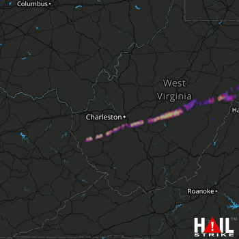 CHARLESTON (KRLX) RADAR
States Impacted By Hail On April 5, 2025
Kentucky
·
Ohio
·
Virginia
·
West Virginia
Counties Impacted By Hail On April 5, 2025
Bourbon, KY
·
Madison, KY
·
Vinton, OH
·
Highland, VA
·
Rockingham, VA
·
Boone, WV
·
Clay, WV
·
Grant, WV
·
Kanawha, WV
·
Lincoln, WV
·
Nicholas, WV
·
Pendleton, WV
·
Pocahontas, WV
·
Randolph, WV
·
Wayne, WV
·
Webster, WV
Cities Impacted By Hail On April 5, 2025
Addison (Webster Springs), WV
·
Belle, WV
·
Camden-on-Gauley, WV
·
Cedar Grove, WV
·
Chelyan, WV
·
Chesapeake, WV
·
Cowen, WV
·
Dixie, WV
·
East Bank, WV
·
Glasgow, WV
·
Harts, WV
·
Marmet, WV
·
Paris, KY
·
Pickens, WV
·
Rand, WV
·
Shrewsbury, WV
·
Summersville, WV
·
Tioga, WV
·
Valley Head, WV
·
Whitmer, WV
Zip Codes Impacted By Hail On April 5, 2025
22831
·
24413
·
24433
·
24442
·
24458
·
24465
·
24915
·
24927
·
24934
·
24944
·
24954
·
25003
·
25009
·
25015
·
25019
·
25025
·
25035
·
25039
·
25043
·
25045
·
25051
·
25053
·
25059
·
25067
·
25086
·
25088
·
25103
·
25107
·
25110
·
25111
·
25132
·
25134
·
25142
·
25154
·
25160
·
25162
·
25169
·
25214
·
25304
·
25306
·
25314
·
25315
·
25501
·
25506
·
25511
·
25524
·
25529
·
25534
·
25557
·
25564
·
25565
·
25567
·
25699
·
26203
·
26205
·
26206
·
26208
·
26217
·
26222
·
26253
·
26263
·
26264
·
26266
·
26268
·
26270
·
26273
·
26280
·
26282
·
26288
·
26294
·
26296
·
26610
·
26651
·
26656
·
26660
·
26691
·
26802
·
26804
·
26807
·
26814
·
26847
·
26855
·
26884
·
40361
·
40475
·
45622
·
45651
·
45654
·
22830
·
24920
·
25061
·
25125
·
26230
·
26690
·
26866

