This weather event on April 1, 2025 includes:
3 states
22 counties,
25 cities,
and 68 zip codes.
There were 257 total properties that were impacted and have possible damage.
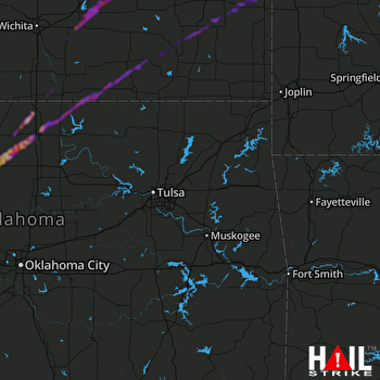 TULSA (KINX) RADAR
States Impacted By Hail On April 1, 2025
Kansas
·
Missouri
·
Oklahoma
Counties Impacted By Hail On April 1, 2025
Allen, KS
·
Bourbon, KS
·
Butler, KS
·
Chautauqua, KS
·
Coffey, KS
·
Cowley, KS
·
Elk, KS
·
Greenwood, KS
·
Linn, KS
·
Lyon, KS
·
Montgomery, KS
·
Neosho, KS
·
Sumner, KS
·
Wilson, KS
·
Woodson, KS
·
Bates, MO
·
Vernon, MO
·
Garfield, OK
·
Grant, OK
·
Kay, OK
·
Noble, OK
·
Osage, OK
Cities Impacted By Hail On April 1, 2025
Altoona, KS
·
Blackwell, OK
·
Breckenridge, OK
·
Burlington, KS
·
Chanute, KS
·
Deer Creek, OK
·
Drummond, OK
·
El Dorado, KS
·
Elsmore, KS
·
Enid, OK
·
Fredonia, KS
·
Fulton, KS
·
Geuda Springs, KS
·
Hunter, OK
·
Kremlin, OK
·
Longton, KS
·
Nardin, OK
·
Newkirk, OK
·
New Strawn, KS
·
North Enid, OK
·
Rosalia, KS
·
Savonburg, KS
·
Tonkawa, OK
·
Uniontown, KS
·
Waukomis, OK
Zip Codes Impacted By Hail On April 1, 2025
64778
·
66701
·
66710
·
66714
·
66716
·
66720
·
66732
·
66733
·
66736
·
66748
·
66754
·
66755
·
66757
·
66761
·
66769
·
66772
·
66779
·
66839
·
66842
·
66852
·
66853
·
66854
·
67005
·
67010
·
67024
·
67038
·
67042
·
67045
·
67051
·
67074
·
67119
·
67132
·
67133
·
67352
·
74630
·
74631
·
74632
·
74636
·
74640
·
74643
·
74646
·
74652
·
74653
·
64752
·
64779
·
66738
·
66758
·
66767
·
66860
·
66871
·
67039
·
67344
·
67345
·
67346
·
67353
·
67361
·
73701
·
73703
·
73705
·
73735
·
73738
·
73753
·
73754
·
73759
·
73766
·
73773
·
74601
·
74647

