This weather event on March 27, 2025 includes:
4 states
22 counties,
24 cities,
and 80 zip codes.
There were 3857 total properties that were impacted and have possible damage.
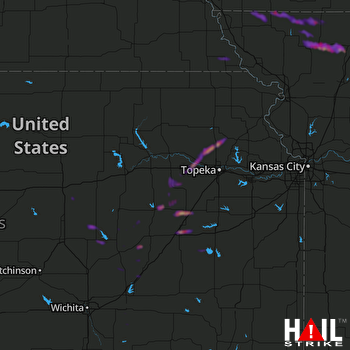 TOPEKA (KTWX) RADAR
States Impacted By Hail On March 27, 2025
Iowa
·
Kansas
·
Missouri
·
Nebraska
Counties Impacted By Hail On March 27, 2025
Page, IA
·
Taylor, IA
·
Butler, KS
·
Chase, KS
·
Coffey, KS
·
Geary, KS
·
Jackson, KS
·
Jefferson, KS
·
Lyon, KS
·
Marion, KS
·
Morris, KS
·
Saline, KS
·
Shawnee, KS
·
Wabaunsee, KS
·
Atchison, MO
·
Daviess, MO
·
Gentry, MO
·
Harrison, MO
·
Nodaway, MO
·
Worth, MO
·
Gage, NE
·
Richardson, NE
Cities Impacted By Hail On March 27, 2025
Admire, KS
·
Albany, MO
·
Allen, KS
·
Alma, KS
·
Blanchard, IA
·
Blanchard, MO
·
Braddyville, IA
·
Burns, KS
·
Clearmont, MO
·
Darlington, MO
·
Durham, KS
·
Elmo, MO
·
Emporia, KS
·
Grant City, MO
·
Hillsboro, KS
·
Hopkins, MO
·
Jameson, MO
·
Lincolnville, KS
·
Maple Hill, KS
·
Marion, KS
·
New Hampton, MO
·
Rossville, KS
·
Salina, KS
·
Verdon, NE
Zip Codes Impacted By Hail On March 27, 2025
51631
·
51636
·
51647
·
64402
·
64424
·
64428
·
64431
·
64438
·
64441
·
64445
·
64456
·
64461
·
64471
·
64475
·
64476
·
64636
·
64640
·
64648
·
64657
·
66088
·
66401
·
66418
·
66419
·
66423
·
66440
·
66507
·
66509
·
66523
·
66526
·
66533
·
66539
·
66615
·
66618
·
66801
·
66830
·
66833
·
66834
·
66835
·
66838
·
66839
·
66840
·
66842
·
66843
·
66845
·
66849
·
66850
·
66851
·
66854
·
66856
·
66858
·
66861
·
66866
·
67008
·
67010
·
67039
·
67063
·
67074
·
67401
·
67438
·
67448
·
67483
·
68318
·
68355
·
68381
·
68431
·
68433
·
68457
·
50833
·
51630
·
64453
·
64479
·
64486
·
64489
·
64498
·
64499
·
64642
·
64647
·
66846
·
66868
·
66873

