This weather event on March 22, 2025 includes:
2 states
22 counties,
30 cities,
and 77 zip codes.
There were 3282 total properties that were impacted and have possible damage.
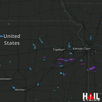 TOPEKA (KTWX) RADAR
States Impacted By Hail On March 22, 2025
Kansas
·
Missouri
Counties Impacted By Hail On March 22, 2025
Allen, KS
·
Anderson, KS
·
Bourbon, KS
·
Chase, KS
·
Coffey, KS
·
Dickinson, KS
·
Douglas, KS
·
Franklin, KS
·
Linn, KS
·
Lyon, KS
·
Marion, KS
·
Miami, KS
·
Morris, KS
·
Osage, KS
·
Wabaunsee, KS
·
Bates, MO
·
Cass, MO
·
Cedar, MO
·
Henry, MO
·
Johnson, MO
·
Ray, MO
·
Vernon, MO
Cities Impacted By Hail On March 22, 2025
Adrian, MO
·
Americus, KS
·
Amsterdam, MO
·
Archie, MO
·
Baldwin City, KS
·
Burlingame, KS
·
Burlington, KS
·
Butler, MO
·
Cleveland, MO
·
Clinton, MO
·
El Dorado Springs, MO
·
Garden City, MO
·
Harrisonville, MO
·
Hillsdale, KS
·
Holden, MO
·
Louisburg, KS
·
Lyndon, KS
·
Merwin, MO
·
Nevada, MO
·
Osage City, KS
·
Osawatomie, KS
·
Ottawa, KS
·
Paola, KS
·
Passaic, MO
·
Peculiar, MO
·
Pomona, KS
·
Rich Hill, MO
·
Urich, MO
·
Vassar, KS
·
Wellsville, KS
Zip Codes Impacted By Hail On March 22, 2025
64061
·
64078
·
64085
·
64637
·
64668
·
64701
·
64720
·
64722
·
64723
·
64725
·
64726
·
64730
·
64734
·
64735
·
64739
·
64742
·
64744
·
64747
·
64750
·
64770
·
64772
·
64779
·
64790
·
66006
·
66013
·
66040
·
66053
·
66064
·
66067
·
66071
·
66076
·
66080
·
66083
·
66091
·
66092
·
66093
·
66401
·
66413
·
66423
·
66431
·
66451
·
66523
·
66524
·
66528
·
66537
·
66834
·
66835
·
66839
·
66845
·
66846
·
66849
·
67449
·
67451
·
64019
·
64035
·
64040
·
64752
·
64780
·
64788
·
66021
·
66032
·
66033
·
66543
·
66716
·
66738
·
66754
·
66767
·
66779
·
66801
·
66830
·
66833
·
66850
·
66858
·
66861
·
66868
·
66869
·
66872

