This weather event on December 27, 2024 includes:
2 states
10 counties,
33 cities,
and 64 zip codes.
There were 529 total properties that were impacted and have possible damage.
States Impacted By Hail On December 27, 2024
Alabama
·
Florida
Counties Impacted By Hail On December 27, 2024
Baldwin, AL
·
Crenshaw, AL
·
Dallas, AL
·
Escambia, AL
·
Mobile, AL
·
Monroe, AL
·
Montgomery, AL
·
Pike, AL
·
Escambia, FL
·
Santa Rosa, FL
Cities Impacted By Hail On December 27, 2024
Atmore, AL
·
Avalon, FL
·
Bagdad, FL
·
Bayou La Batre, AL
·
Daphne, AL
·
East Milton, FL
·
Elberta, AL
·
Fairhope, AL
·
Ferry Pass, FL
·
Foley, AL
·
Gonzalez, FL
·
Grand Bay, AL
·
Gulf Shores, AL
·
Loxley, AL
·
Luverne, AL
·
Mobile, AL
·
Mulat, FL
·
Orange Beach, AL
·
Pace, FL
·
Pea Ridge, FL
·
Pensacola, FL
·
Pike Road, AL
·
Point Clear, AL
·
Prichard, AL
·
Robertsdale, AL
·
Semmes, AL
·
Silverhill, AL
·
Spanish Fort, AL
·
Stapleton, AL
·
Summerdale, AL
·
Tillmans Corner, AL
·
Troy, AL
·
Wallace, FL
Zip Codes Impacted By Hail On December 27, 2024
32504
·
32514
·
32533
·
32534
·
32568
·
32570
·
32571
·
32577
·
32583
·
36046
·
36049
·
36052
·
36064
·
36069
·
36079
·
36105
·
36116
·
36480
·
36502
·
36507
·
36509
·
36523
·
36526
·
36527
·
36530
·
36532
·
36535
·
36541
·
36542
·
36543
·
36549
·
36551
·
36559
·
36561
·
36562
·
36564
·
36567
·
36574
·
36575
·
36576
·
36578
·
36579
·
36580
·
36582
·
36587
·
36602
·
36603
·
36604
·
36605
·
36606
·
36607
·
36608
·
36609
·
36610
·
36612
·
36613
·
36615
·
36617
·
36618
·
36619
·
36693
·
36695
·
36761
·
36767
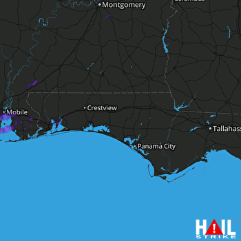 EGLIN AFB (KEVX) RADAR

