This weather event on September 22, 2024 includes:
1 states
36 counties,
9 cities,
and 64 zip codes.
There were 19 total properties that were impacted and have possible damage.
States Impacted By Hail On September 22, 2024
Texas
Counties Impacted By Hail On September 22, 2024
Borden, TX
·
Brown, TX
·
Callahan, TX
·
Coke, TX
·
Coleman, TX
·
Comanche, TX
·
Crane, TX
·
Crockett, TX
·
Dickens, TX
·
Eastland, TX
·
Erath, TX
·
Fisher, TX
·
Garza, TX
·
Glasscock, TX
·
Haskell, TX
·
Howard, TX
·
Irion, TX
·
Jones, TX
·
Kent, TX
·
Martin, TX
·
Mitchell, TX
·
Nolan, TX
·
Pecos, TX
·
Reagan, TX
·
Runnels, TX
·
Scurry, TX
·
Shackelford, TX
·
Stephens, TX
·
Sterling, TX
·
Stonewall, TX
·
Taylor, TX
·
Terrell, TX
·
Throckmorton, TX
·
Tom Green, TX
·
Upton, TX
·
Young, TX
Cities Impacted By Hail On September 22, 2024
Big Spring, TX
·
Dublin, TX
·
Rankin, TX
·
Rising Star, TX
·
Sanderson, TX
·
Sand Springs, TX
·
Snyder, TX
·
Stamford, TX
·
Woodson, TX
Zip Codes Impacted By Hail On September 22, 2024
76424
·
76430
·
76442
·
76443
·
76444
·
76446
·
76471
·
76483
·
76491
·
76801
·
76828
·
76834
·
76857
·
76905
·
76932
·
76941
·
76943
·
76945
·
76951
·
79330
·
79356
·
79370
·
79502
·
79503
·
79506
·
79511
·
79512
·
79517
·
79518
·
79520
·
79521
·
79525
·
79527
·
79528
·
79533
·
79534
·
79535
·
79537
·
79538
·
79541
·
79543
·
79546
·
79549
·
79553
·
79556
·
79560
·
79561
·
79566
·
79567
·
79601
·
79720
·
79731
·
79735
·
79739
·
79744
·
79749
·
79752
·
79755
·
79781
·
79782
·
79848
·
76933
·
79501
·
79778
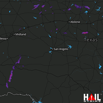 SAN ANGELO (KSJT) RADAR

