This weather event on August 15, 2024 includes:
1 states
18 counties,
20 cities,
and 56 zip codes.
There were 186 total properties that were impacted and have possible damage.
States Impacted By Hail On August 15, 2024
Nebraska
Counties Impacted By Hail On August 15, 2024
Antelope, NE
·
Boone, NE
·
Buffalo, NE
·
Butler, NE
·
Cuming, NE
·
Dodge, NE
·
Garfield, NE
·
Hall, NE
·
Holt, NE
·
Madison, NE
·
Merrick, NE
·
Pierce, NE
·
Platte, NE
·
Polk, NE
·
Saunders, NE
·
Stanton, NE
·
Wayne, NE
·
Wheeler, NE
Cities Impacted By Hail On August 15, 2024
Abie, NE
·
Bruno, NE
·
Brunswick, NE
·
Clearwater, NE
·
Ewing, NE
·
Foster, NE
·
Hoskins, NE
·
Inman, NE
·
Lindsay, NE
·
Meadow Grove, NE
·
Neligh, NE
·
Newman Grove, NE
·
Oakdale, NE
·
Petersburg, NE
·
Pierce, NE
·
Pilger, NE
·
Plainview, NE
·
Tilden, NE
·
Winside, NE
·
Woodland Park, NE
Zip Codes Impacted By Hail On August 15, 2024
68001
·
68014
·
68015
·
68036
·
68050
·
68621
·
68622
·
68626
·
68627
·
68628
·
68632
·
68636
·
68644
·
68648
·
68649
·
68651
·
68652
·
68660
·
68663
·
68701
·
68711
·
68713
·
68715
·
68720
·
68723
·
68725
·
68726
·
68729
·
68735
·
68740
·
68742
·
68752
·
68756
·
68758
·
68761
·
68763
·
68764
·
68765
·
68766
·
68767
·
68768
·
68769
·
68771
·
68773
·
68779
·
68781
·
68787
·
68790
·
68791
·
68823
·
68824
·
68869
·
68876
·
68883
·
68642
·
68620
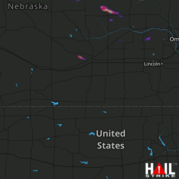 HASTINGS (KUEX) RADAR

