This weather event on August 7, 2024 includes:
2 states
25 counties,
12 cities,
and 61 zip codes.
There were 1020 total properties that were impacted and have possible damage.
States Impacted By Hail On August 7, 2024
Iowa
·
Nebraska
Counties Impacted By Hail On August 7, 2024
Cherokee, IA
·
Plymouth, IA
·
Sioux, IA
·
Adams, NE
·
Antelope, NE
·
Boone, NE
·
Buffalo, NE
·
Butler, NE
·
Colfax, NE
·
Cuming, NE
·
Garfield, NE
·
Greeley, NE
·
Hall, NE
·
Holt, NE
·
Howard, NE
·
Kearney, NE
·
Madison, NE
·
Merrick, NE
·
Nance, NE
·
Platte, NE
·
Polk, NE
·
Saunders, NE
·
Stanton, NE
·
Valley, NE
·
Wheeler, NE
Cities Impacted By Hail On August 7, 2024
Belgrade, NE
·
Creston, NE
·
Cushing, NE
·
Duncan, NE
·
Ericson, NE
·
Genoa, NE
·
Grand Island, NE
·
Greeley Center, NE
·
Memphis, NE
·
Monroe, NE
·
Petersburg, NE
·
Wood River, NE
Zip Codes Impacted By Hail On August 7, 2024
51003
·
51012
·
51014
·
51031
·
51037
·
51041
·
51050
·
68003
·
68042
·
68601
·
68620
·
68622
·
68623
·
68624
·
68629
·
68631
·
68632
·
68633
·
68634
·
68636
·
68637
·
68638
·
68640
·
68641
·
68643
·
68644
·
68647
·
68651
·
68652
·
68653
·
68655
·
68660
·
68662
·
68663
·
68665
·
68701
·
68726
·
68735
·
68742
·
68756
·
68758
·
68763
·
68779
·
68788
·
68801
·
68823
·
68828
·
68837
·
68840
·
68842
·
68862
·
68864
·
68869
·
68873
·
68875
·
68876
·
68882
·
68883
·
68956
·
68959
·
68642
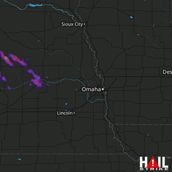 OMAHA (KOAX) RADAR

