This weather event on May 27, 2024 includes:
1 states
28 counties,
16 cities,
and 58 zip codes.
There were 875 total properties that were impacted and have possible damage.
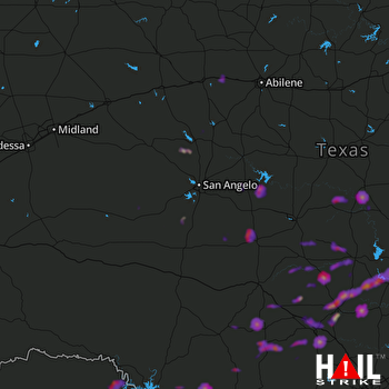 SAN ANGELO (KSJT) RADAR
States Impacted By Hail On May 27, 2024
Texas
Counties Impacted By Hail On May 27, 2024
Bandera, TX
·
Blanco, TX
·
Burnet, TX
·
Coke, TX
·
Concho, TX
·
Crockett, TX
·
Edwards, TX
·
Fisher, TX
·
Gillespie, TX
·
Irion, TX
·
Jones, TX
·
Kendall, TX
·
Kerr, TX
·
Kimble, TX
·
Kinney, TX
·
Lampasas, TX
·
Llano, TX
·
Mason, TX
·
McCulloch, TX
·
Menard, TX
·
Mills, TX
·
Nolan, TX
·
Real, TX
·
San Saba, TX
·
Schleicher, TX
·
Taylor, TX
·
Tom Green, TX
·
Val Verde, TX
Cities Impacted By Hail On May 27, 2024
Camp Wood, TX
·
Cottonwood Shores, TX
·
Fredericksburg, TX
·
Granite Shoals, TX
·
Harper, TX
·
Highland Haven, TX
·
Horseshoe Bay, TX
·
Kerrville, TX
·
Llano, TX
·
Marble Falls, TX
·
Meadowlakes, TX
·
Richland Springs, TX
·
San Angelo, TX
·
Stonewall, TX
·
Sunrise Beach Village, TX
·
Trent, TX
Zip Codes Impacted By Hail On May 27, 2024
76825
·
76831
·
76837
·
76841
·
76842
·
76844
·
76849
·
76856
·
76859
·
76862
·
76866
·
76869
·
76871
·
76877
·
76885
·
76887
·
76903
·
76904
·
76930
·
76933
·
76935
·
76936
·
76941
·
76943
·
76945
·
78833
·
78010
·
78013
·
78024
·
78025
·
78028
·
78055
·
78058
·
78611
·
78618
·
78624
·
78631
·
78635
·
78636
·
78639
·
78643
·
78654
·
78657
·
78663
·
78671
·
78675
·
78828
·
78832
·
78840
·
78873
·
78880
·
78883
·
78885
·
79506
·
79536
·
79561
·
78003
·
76853

