This weather event on May 26, 2024 includes:
2 states
23 counties,
24 cities,
and 74 zip codes.
There were 1533 total properties that were impacted and have possible damage.
States Impacted By Hail On May 26, 2024
North Carolina
·
Virginia
Counties Impacted By Hail On May 26, 2024
Cumberland, NC
·
Durham, NC
·
Edgecombe, NC
·
Franklin, NC
·
Granville, NC
·
Halifax, NC
·
Harnett, NC
·
Hoke, NC
·
Johnston, NC
·
Lee, NC
·
Moore, NC
·
Nash, NC
·
Northampton, NC
·
Robeson, NC
·
Sampson, NC
·
Scotland, NC
·
Vance, NC
·
Wake, NC
·
Warren, NC
·
Wayne, NC
·
Wilson, NC
·
Brunswick, VA
·
Greensville, VA
Cities Impacted By Hail On May 26, 2024
Archer Lodge, NC
·
Black Creek, NC
·
Bonnetsville, NC
·
Bunn, NC
·
Bunnlevel, NC
·
Centerville, NC
·
Clayton, NC
·
Clinton, NC
·
Eastover, NC
·
Franklinton, NC
·
Gaston, NC
·
Kenly, NC
·
Lake Royale, NC
·
Lucama, NC
·
Maxton, NC
·
Nashville, NC
·
Red Oak, NC
·
Roanoke Rapids, NC
·
Sanford, NC
·
Spring Lake, NC
·
Wade, NC
·
Wake Forest, NC
·
Wilson, NC
·
Youngsville, NC
Zip Codes Impacted By Hail On May 26, 2024
23847
·
23868
·
23879
·
23887
·
27330
·
27332
·
27505
·
27508
·
27522
·
27524
·
27525
·
27527
·
27537
·
27544
·
27546
·
27549
·
27557
·
27563
·
27576
·
27587
·
27589
·
27591
·
27597
·
27613
·
27614
·
27703
·
27704
·
27804
·
27807
·
27816
·
27822
·
27823
·
27829
·
27830
·
27831
·
27832
·
27842
·
27844
·
27850
·
27851
·
27852
·
27853
·
27856
·
27863
·
27864
·
27866
·
27870
·
27876
·
27880
·
27882
·
27883
·
27891
·
27893
·
27896
·
28307
·
28311
·
28315
·
28323
·
28328
·
28334
·
28339
·
28344
·
28352
·
28356
·
28364
·
28390
·
28394
·
28395
·
28396
·
28366
·
28326
·
27596
·
27542
·
27504
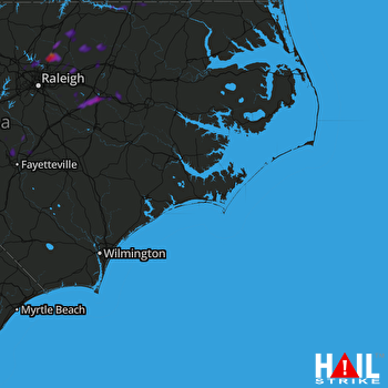 MOREHEAD CITY (KMHX) RADAR

