This weather event on May 22, 2024 includes:
3 states
24 counties,
29 cities,
and 69 zip codes.
There were 31749 total properties that were impacted and have possible damage.
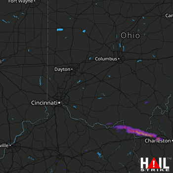 CINCINNATI (KILN) RADAR
States Impacted By Hail On May 22, 2024
Kentucky
·
Ohio
·
West Virginia
Counties Impacted By Hail On May 22, 2024
Bath, KY
·
Bourbon, KY
·
Boyd, KY
·
Boyle, KY
·
Clark, KY
·
Fayette, KY
·
Fleming, KY
·
Garrard, KY
·
Greenup, KY
·
Jessamine, KY
·
Lewis, KY
·
Madison, KY
·
Woodford, KY
·
Adams, OH
·
Athens, OH
·
Lawrence, OH
·
Meigs, OH
·
Scioto, OH
·
Vinton, OH
·
Cabell, WV
·
Kanawha, WV
·
Lincoln, WV
·
Mason, WV
·
Putnam, WV
Cities Impacted By Hail On May 22, 2024
Ashland, KY
·
Athalia, OH
·
Barboursville, WV
·
Bellefonte, KY
·
Coal Grove, OH
·
Culloden, WV
·
Flatwoods, KY
·
Franklin Furnace, OH
·
Garrison, KY
·
Greenup, KY
·
Hanging Rock, OH
·
Huntington, WV
·
Hurricane, WV
·
Ironton, OH
·
Lesage, WV
·
Lexington-Fayette, KY
·
Milton, WV
·
Nicholasville, KY
·
Paris, KY
·
Pea Ridge, WV
·
Raceland, KY
·
Richmond, KY
·
Russell, KY
·
South Point, OH
·
Stewart, OH
·
Westwood, KY
·
Wilkesville, OH
·
Worthington, KY
·
Wurtland, KY
Zip Codes Impacted By Hail On May 22, 2024
25082
·
25106
·
25123
·
25177
·
25241
·
25504
·
25510
·
25515
·
25520
·
25526
·
25537
·
25541
·
25545
·
25550
·
25560
·
25702
·
25705
·
40311
·
40339
·
40356
·
40360
·
40361
·
40374
·
40383
·
40390
·
40422
·
40444
·
40475
·
40511
·
40515
·
40516
·
41041
·
41049
·
41101
·
41102
·
41121
·
41139
·
41141
·
41144
·
41166
·
41169
·
41174
·
41175
·
41179
·
41183
·
45144
·
45616
·
45619
·
45623
·
45629
·
45636
·
45638
·
45645
·
45659
·
45663
·
45669
·
45678
·
45680
·
45684
·
45686
·
45695
·
45696
·
45710
·
45723
·
45735
·
45741
·
45769
·
45776
·
45778

