This weather event on April 28, 2024 includes:
3 states
15 counties,
28 cities,
and 56 zip codes.
There were 377 total properties that were impacted and have possible damage.
States Impacted By Hail On April 28, 2024
Arkansas
·
Missouri
·
Oklahoma
Counties Impacted By Hail On April 28, 2024
Carroll, AR
·
Crawford, AR
·
Franklin, AR
·
Johnson, AR
·
Logan, AR
·
Madison, AR
·
Newton, AR
·
Polk, AR
·
Pope, AR
·
Sebastian, AR
·
Washington, AR
·
Stone, MO
·
Adair, OK
·
Le Flore, OK
·
Sequoyah, OK
Cities Impacted By Hail On April 28, 2024
Arkoma, OK
·
Belfonte, OK
·
Bell, OK
·
Blue Eye, AR
·
Blue Eye, MO
·
Cedarville, AR
·
Elm Grove, OK
·
Farmington, AR
·
Fort Smith, AR
·
Hartford, AR
·
Liberty, OK
·
Long, OK
·
Moffett, OK
·
Nicut, OK
·
Oak Grove, AR
·
Paris, AR
·
Pocola, OK
·
Poteau, OK
·
Prairie Grove, AR
·
Remy, OK
·
Roland, OK
·
Rudy, AR
·
Salem, OK
·
Shady Point, OK
·
Short, OK
·
Stoney Point, OK
·
Van Buren, AR
·
Winslow, AR
Zip Codes Impacted By Hail On April 28, 2024
65611
·
71945
·
71953
·
72616
·
72628
·
72638
·
72641
·
72660
·
72701
·
72727
·
72729
·
72730
·
72740
·
72752
·
72753
·
72774
·
72776
·
72830
·
72839
·
72852
·
72854
·
72855
·
72856
·
72901
·
72903
·
72904
·
72916
·
72921
·
72927
·
72932
·
72933
·
72934
·
72936
·
72937
·
72938
·
72946
·
72948
·
72952
·
72955
·
72956
·
72959
·
74901
·
74902
·
74931
·
74932
·
74946
·
74948
·
74951
·
74953
·
74954
·
74955
·
74956
·
74957
·
74959
·
74960
·
72717
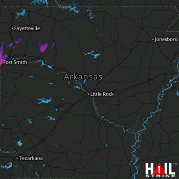 LITTLE ROCK (KLZK) RADAR

