This weather event on April 27, 2024 includes:
1 states
25 counties,
22 cities,
and 69 zip codes.
There were 1902 total properties that were impacted and have possible damage.
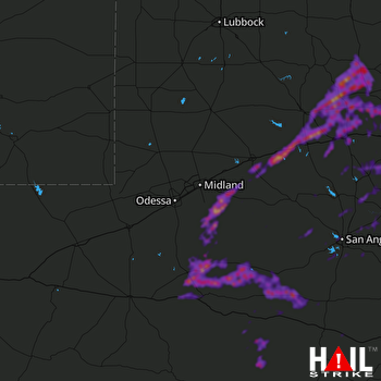 MIDLAND/ODSSA (KMAF) RADAR
States Impacted By Hail On April 27, 2024
Texas
Counties Impacted By Hail On April 27, 2024
Borden, TX
·
Coke, TX
·
Concho, TX
·
Crockett, TX
·
Fisher, TX
·
Glasscock, TX
·
Howard, TX
·
Irion, TX
·
Jones, TX
·
Kent, TX
·
Midland, TX
·
Mitchell, TX
·
Nolan, TX
·
Pecos, TX
·
Reagan, TX
·
Runnels, TX
·
Schleicher, TX
·
Scurry, TX
·
Sterling, TX
·
Stonewall, TX
·
Sutton, TX
·
Taylor, TX
·
Tom Green, TX
·
Upton, TX
·
Val Verde, TX
Cities Impacted By Hail On April 27, 2024
Abilene, TX
·
Aspermont, TX
·
Big Spring, TX
·
Colorado City, TX
·
Forsan, TX
·
Garden City, TX
·
Hamlin, TX
·
Hermleigh, TX
·
Lake Colorado City, TX
·
Loraine, TX
·
McCamey, TX
·
Miles, TX
·
Ozona, TX
·
Rankin, TX
·
Roby, TX
·
Roscoe, TX
·
Rotan, TX
·
San Angelo, TX
·
Sweetwater, TX
·
Trent, TX
·
Tuscola, TX
·
Westbrook, TX
Zip Codes Impacted By Hail On April 27, 2024
76821
·
76837
·
76861
·
76862
·
76865
·
76866
·
76875
·
76901
·
76903
·
76904
·
76905
·
76930
·
76932
·
76933
·
76935
·
76936
·
76939
·
76941
·
76943
·
76945
·
76950
·
76951
·
76953
·
76955
·
76958
·
79501
·
79502
·
79506
·
79508
·
79511
·
79512
·
79520
·
79525
·
79527
·
79532
·
79534
·
79535
·
79536
·
79537
·
79541
·
79545
·
79546
·
79549
·
79556
·
79560
·
79561
·
79562
·
79563
·
79565
·
79566
·
79567
·
79602
·
79603
·
79606
·
79706
·
79720
·
79731
·
79733
·
79735
·
79739
·
79744
·
79752
·
79755
·
79778
·
79781
·
79782
·
79942
·
79543
·
79526

