Hail Map For October 25, 2026 (KEPZ)

This weather event on October 25, 2026 includes: 2 states 8 counties, 12 cities, and 29 zip codes.
There were 47868 total properties that were impacted and have possible damage.
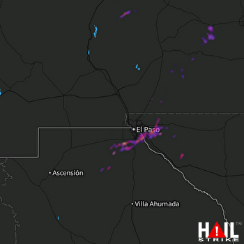
Preview image EL PASO (KEPZ) RADAR
Weather Data Verified By

Data provided by NOAA. Data provided by NWS.

Impact Score

1

Hail Size

Average 1.8"
Maximum 2.5"

Storm Details

Start Time
05:19 PM
Properties
47868
Spotters
1
GROUND VERIFIED

States Impacted By Hail On October 25, 2026

New Mexico · Texas

Counties Impacted By Hail On October 25, 2026

Chaves, NM · Doña Ana, NM · Lincoln, NM · Otero, NM · Sierra, NM · Socorro, NM · El Paso, TX · Hudspeth, TX

Cities Impacted By Hail On October 25, 2026

Agua Dulce, TX · Butterfield, TX · Clint, TX · El Paso, TX · Homestead Meadows North, TX · Horizon City, TX · Sacramento, NM · San Elizario, TX · Socorro, TX · Sparks, TX · Timberon, NM · Weed, NM

Zip Codes Impacted By Hail On October 25, 2026

79836 · 79839 · 79849 · 79851 · 79905 · 79907 · 79915 · 79925 · 79927 · 79928 · 79935 · 79936 · 79938 · 87832 · 87901 · 88021 · 88081 · 88203 · 88310 · 88317 · 88339 · 88340 · 88343 · 88344 · 88347 · 88349 · 88350 · 88351 · 88354