This weather event on October 23, 2026 includes:
2 states
11 counties,
26 cities,
and 73 zip codes.
There were 58447 total properties that were impacted and have possible damage.
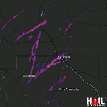 EL PASO (KEPZ) RADAR
States Impacted By Hail On October 23, 2026
New Mexico
·
Texas
Counties Impacted By Hail On October 23, 2026
Catron, NM
·
Doña Ana, NM
·
Grant, NM
·
Hidalgo, NM
·
Lincoln, NM
·
Luna, NM
·
Otero, NM
·
Sierra, NM
·
Socorro, NM
·
El Paso, TX
·
Hudspeth, TX
Cities Impacted By Hail On October 23, 2026
Agua Dulce, TX
·
Alamogordo, NM
·
Arrey, NM
·
Boles Acres, NM
·
Cliff, NM
·
Clint, TX
·
Columbus, NM
·
El Paso, TX
·
Faywood, NM
·
Fort Bliss, TX
·
Gila, NM
·
Hatch, NM
·
Holloman AFB, NM
·
Homestead Meadows North, TX
·
Horizon City, TX
·
La Luz, NM
·
Morning Glory, TX
·
Oasis, NM
·
Salem, NM
·
San Elizario, TX
·
San Miguel, NM
·
Socorro, TX
·
Sparks, TX
·
Sunland Park, NM
·
Timberon, NM
·
Tularosa, NM
Zip Codes Impacted By Hail On October 23, 2026
79835
·
79836
·
79839
·
79849
·
79853
·
79901
·
79902
·
79903
·
79904
·
79905
·
79906
·
79907
·
79908
·
79912
·
79915
·
79916
·
79920
·
79922
·
79924
·
79925
·
79927
·
79928
·
79930
·
79934
·
79935
·
79936
·
79938
·
87825
·
87832
·
87901
·
87930
·
87931
·
87933
·
87936
·
87937
·
87941
·
87943
·
88007
·
88008
·
88011
·
88021
·
88025
·
88027
·
88028
·
88029
·
88030
·
88034
·
88038
·
88039
·
88041
·
88042
·
88043
·
88044
·
88045
·
88047
·
88048
·
88055
·
88061
·
88063
·
88081
·
88310
·
88311
·
88314
·
88316
·
88325
·
88330
·
88337
·
88338
·
88347
·
88350
·
88351
·
88352
·
88354