This weather event on October 22, 2026 includes:
2 states
13 counties,
33 cities,
and 66 zip codes.
There were 6769 total properties that were impacted and have possible damage.
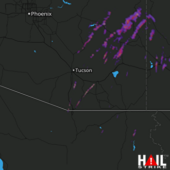 TUCSON (KEMX) RADAR
States Impacted By Hail On October 22, 2026
Arizona
·
New Mexico
Counties Impacted By Hail On October 22, 2026
Apache, AZ
·
Cochise, AZ
·
Gila, AZ
·
Graham, AZ
·
Greenlee, AZ
·
Maricopa, AZ
·
Navajo, AZ
·
Pima, AZ
·
Pinal, AZ
·
Santa Cruz, AZ
·
Catron, NM
·
Grant, NM
·
Hidalgo, NM
Cities Impacted By Hail On October 22, 2026
Benson, AZ
·
Beyerville, AZ
·
Bryce, AZ
·
Bylas, AZ
·
Catalina Foothills, AZ
·
Central, AZ
·
Cliff, NM
·
Clifton, AZ
·
Fort Thomas, AZ
·
Gila, NM
·
Glenwood, NM
·
Green Valley, AZ
·
Lordsburg, NM
·
Mammoth, AZ
·
Morenci, AZ
·
Nogales, AZ
·
Oracle, AZ
·
Patagonia, AZ
·
Phoenix, AZ
·
Pima, AZ
·
Pleasanton, NM
·
Rio Rico, AZ
·
Rodeo, NM
·
Safford, AZ
·
Sahuarita, AZ
·
San Jose, AZ
·
Solomon, AZ
·
Sonoita, AZ
·
Swift Trail Junction, AZ
·
Thatcher, AZ
·
Tucson, AZ
·
Tumacacori-Carmen, AZ
·
White Signal, NM
Zip Codes Impacted By Hail On October 22, 2026
85020
·
85022
·
85028
·
85032
·
85192
·
85530
·
85531
·
85533
·
85534
·
85535
·
85536
·
85540
·
85542
·
85543
·
85546
·
85551
·
85552
·
85602
·
85603
·
85605
·
85606
·
85607
·
85609
·
85610
·
85611
·
85614
·
85615
·
85618
·
85619
·
85621
·
85623
·
85624
·
85625
·
85629
·
85630
·
85631
·
85637
·
85638
·
85640
·
85641
·
85643
·
85645
·
85646
·
85648
·
85706
·
85710
·
85718
·
85730
·
85739
·
85748
·
85749
·
85750
·
85756
·
85922
·
85941
·
88009
·
88020
·
88025
·
88028
·
88038
·
88039
·
88045
·
88051
·
88055
·
88056
·
88061