This weather event on September 23, 2026 includes:
3 states
20 counties,
14 cities,
and 62 zip codes.
There were 2006 total properties that were impacted and have possible damage.
States Impacted By Hail On September 23, 2026
Kentucky
·
Ohio
·
West Virginia
Counties Impacted By Hail On September 23, 2026
Elliott, KY
·
Harlan, KY
·
Knott, KY
·
Leslie, KY
·
Letcher, KY
·
Martin, KY
·
Perry, KY
·
Rowan, KY
·
Adams, OH
·
Fayette, OH
·
Highland, OH
·
Pike, OH
·
Ross, OH
·
Scioto, OH
·
Boone, WV
·
Calhoun, WV
·
Lincoln, WV
·
Logan, WV
·
Roane, WV
·
Wayne, WV
Cities Impacted By Hail On September 23, 2026
Blackey, KY
·
Chapmanville, WV
·
Clarktown, OH
·
Greenfield, OH
·
Highland Holiday, OH
·
Hillsboro, OH
·
Hindman, KY
·
Lucasville, OH
·
Rocky Fork Point, OH
·
South Wallins, KY
·
Stockdale, OH
·
Wallins Creek, KY
·
Washington Court House, OH
·
Winchester, OH
Zip Codes Impacted By Hail On September 23, 2026
25053
·
25235
·
25266
·
25501
·
25506
·
25508
·
25511
·
25512
·
25521
·
25523
·
25529
·
25534
·
25540
·
25557
·
25565
·
25573
·
40351
·
40810
·
40823
·
40824
·
40827
·
40865
·
40868
·
40870
·
40873
·
41171
·
41231
·
41250
·
41731
·
41749
·
41759
·
41773
·
41774
·
41804
·
41817
·
41821
·
41822
·
41826
·
41831
·
41832
·
41834
·
41836
·
41839
·
41844
·
41847
·
41848
·
43135
·
43160
·
45123
·
45133
·
45135
·
45601
·
45612
·
45613
·
45644
·
45648
·
45653
·
45661
·
45679
·
45681
·
45690
·
45697
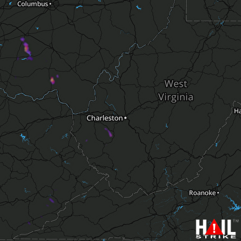 CHARLESTON (KRLX) RADAR

