This weather event on September 6, 2026 includes:
4 states
31 counties,
22 cities,
and 73 zip codes.
There were 207 total properties that were impacted and have possible damage.
States Impacted By Hail On September 6, 2026
North Carolina
·
Tennessee
·
Virginia
·
West Virginia
Counties Impacted By Hail On September 6, 2026
Alleghany, NC
·
Ashe, NC
·
Avery, NC
·
Buncombe, NC
·
Burke, NC
·
Caldwell, NC
·
Catawba, NC
·
Cleveland, NC
·
Lee, NC
·
McDowell, NC
·
Mitchell, NC
·
Montgomery, NC
·
Moore, NC
·
Richmond, NC
·
Rutherford, NC
·
Watauga, NC
·
Wilkes, NC
·
Yancey, NC
·
Unicoi, TN
·
Washington, TN
·
Bland, VA
·
Carroll, VA
·
Floyd, VA
·
Giles, VA
·
Grayson, VA
·
Montgomery, VA
·
Pulaski, VA
·
Radford, VA
·
Smyth, VA
·
Wythe, VA
·
Greenbrier, WV
Cities Impacted By Hail On September 6, 2026
Atkins, VA
·
Belview, VA
·
Boiling Springs, NC
·
Bostic, NC
·
Fairlawn, VA
·
Foxfire, NC
·
Lattimore, NC
·
Marion, NC
·
Marion, VA
·
Mooresboro, NC
·
Mulberry, NC
·
Norman, NC
·
Old Fort, NC
·
Plum Creek, VA
·
Radford, VA
·
Sanford, NC
·
Seven Lakes, NC
·
Shelby, NC
·
Star, NC
·
Sugar Grove, VA
·
Troutdale, VA
·
West Marion, NC
Zip Codes Impacted By Hail On September 6, 2026
24060
·
24073
·
24105
·
24128
·
24136
·
24141
·
24149
·
24311
·
24315
·
24318
·
24325
·
24343
·
24347
·
24348
·
24352
·
24354
·
24363
·
24368
·
24370
·
24375
·
24378
·
24380
·
24382
·
24901
·
24938
·
24966
·
24986
·
24991
·
27229
·
27242
·
27281
·
27330
·
27332
·
27356
·
27376
·
28017
·
28018
·
28020
·
28040
·
28043
·
28089
·
28114
·
28139
·
28150
·
28152
·
28167
·
28315
·
28327
·
28338
·
28367
·
28602
·
28611
·
28612
·
28618
·
28624
·
28644
·
28645
·
28649
·
28655
·
28657
·
28659
·
28663
·
28675
·
28705
·
28709
·
28714
·
28749
·
28752
·
28761
·
28762
·
28777
·
37650
·
37659
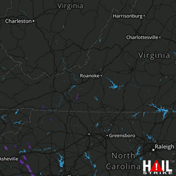 ROANOKE (KFCX) RADAR

